


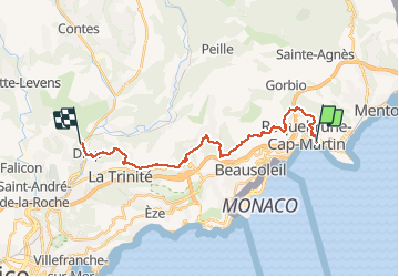
Via Aurelia de Roquebrune à Drap

PEBREJOSIANE
Gebruiker

Lengte
22 km

Max. hoogte
793 m

Positief hoogteverschil
1019 m
Km-Effort
36 km

Min. hoogte
21 m

Negatief hoogteverschil
943 m
Boucle
Neen
Datum van aanmaak :
2018-04-17 13:03:26.856
Laatste wijziging :
2018-04-17 13:03:26.856
8h04
Moeilijkheid : Gemakkelijk

Gratisgps-wandelapplicatie
 SityTrail
IGN / Geografische instituten
SityTrail Plus
De wereld gaat voor u open
Over ons
Tocht Stappen van 22 km beschikbaar op Provence-Alpes-Côte d'Azur, Alpes-Maritimes, Roquebrune-Cap-Martin. Deze tocht wordt voorgesteld door PEBREJOSIANE.
Beschrijving
superbe rando avec des points de vue majestueux
Plaatsbepaling
Land:
France
Regio :
Provence-Alpes-Côte d'Azur
Departement/Provincie :
Alpes-Maritimes
Gemeente :
Roquebrune-Cap-Martin
Locatie:
Unknown
Vertrek:(Dec)
Vertrek:(UTM)
376218 ; 4846474 (32T) N.
Opmerkingen