


esneux boucle rect jaune

ochelen
Gebruiker
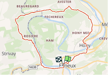

Lengte
10,1 km

Max. hoogte
237 m

Positief hoogteverschil
287 m
Km-Effort
14 km

Min. hoogte
79 m

Negatief hoogteverschil
293 m
Boucle
Ja
Datum van aanmaak :
2018-04-17 13:17:42.756
Laatste wijziging :
2018-04-17 13:17:42.756
2h25
Moeilijkheid : Onbekend

Gratisgps-wandelapplicatie
 SityTrail
IGN / Geografische instituten
SityTrail Plus
De wereld gaat voor u open
Over ons
Tocht Andere activiteiten van 10,1 km beschikbaar op Wallonië, Luik, Esneux. Deze tocht wordt voorgesteld door ochelen.
Beschrijving
marche
Plaatsbepaling
Land:
Belgium
Regio :
Wallonië
Departement/Provincie :
Luik
Gemeente :
Esneux
Locatie:
Esneux
Vertrek:(Dec)
Vertrek:(UTM)
681912 ; 5601017 (31U) N.
Opmerkingen