


Haïssotte

kikkko
Gebruiker

Lengte
8,9 km

Max. hoogte
399 m

Positief hoogteverschil
234 m
Km-Effort
12,1 km

Min. hoogte
272 m

Negatief hoogteverschil
236 m
Boucle
Ja
Datum van aanmaak :
2018-04-17 13:41:42.634
Laatste wijziging :
2018-04-17 13:41:42.634
2h28
Moeilijkheid : Gemakkelijk

Gratisgps-wandelapplicatie
 SityTrail
IGN / Geografische instituten
SityTrail Plus
De wereld gaat voor u open
Over ons
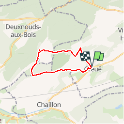
Tocht Stappen van 8,9 km beschikbaar op Grand Est, Meuse, Vigneulles-lès-Hattonchâtel. Deze tocht wordt voorgesteld door kikkko.
Beschrijving
Joli parcours qui permet de découvrir l'abbaye de l'Etanche
Plaatsbepaling
Land:
France
Regio :
Grand Est
Departement/Provincie :
Meuse
Gemeente :
Vigneulles-lès-Hattonchâtel
Locatie:
Unknown
Vertrek:(Dec)
Vertrek:(UTM)
695430 ; 5427029 (31U) N.
Opmerkingen