


Brusque "Coste Calde"

CANON2
Gebruiker
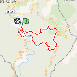

Lengte
6,9 km

Max. hoogte
776 m

Positief hoogteverschil
350 m
Km-Effort
11,6 km

Min. hoogte
462 m

Negatief hoogteverschil
353 m
Boucle
Ja
Datum van aanmaak :
2019-05-15 13:07:46.106
Laatste wijziging :
2019-05-15 13:07:46.251
2h25
Moeilijkheid : Gemakkelijk

Gratisgps-wandelapplicatie
 SityTrail
IGN / Geografische instituten
SityTrail Plus
De wereld gaat voor u open
Over ons
Tocht Stappen van 6,9 km beschikbaar op Occitanië, Aveyron, Brusque. Deze tocht wordt voorgesteld door CANON2.
Plaatsbepaling
Land:
France
Regio :
Occitanië
Departement/Provincie :
Aveyron
Gemeente :
Brusque
Locatie:
Unknown
Vertrek:(Dec)
Vertrek:(UTM)
496593 ; 4844830 (31T) N.
Opmerkingen