


CENGLE

tessonnierg
Gebruiker
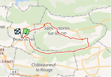

Lengte
17,1 km

Max. hoogte
529 m

Positief hoogteverschil
450 m
Km-Effort
23 km

Min. hoogte
252 m

Negatief hoogteverschil
450 m
Boucle
Ja
Datum van aanmaak :
2018-04-17 16:33:20.045
Laatste wijziging :
2018-04-17 16:33:20.045
5h00
Moeilijkheid : Medium

Gratisgps-wandelapplicatie
 SityTrail
IGN / Geografische instituten
SityTrail Plus
De wereld gaat voor u open
Over ons
Tocht Stappen van 17,1 km beschikbaar op Provence-Alpes-Côte d'Azur, Bouches-du-Rhône, Beaurecueil. Deze tocht wordt voorgesteld door tessonnierg.
Beschrijving
CENGLE
Plaatsbepaling
Land:
France
Regio :
Provence-Alpes-Côte d'Azur
Departement/Provincie :
Bouches-du-Rhône
Gemeente :
Beaurecueil
Locatie:
Unknown
Vertrek:(Dec)
Vertrek:(UTM)
705616 ; 4820823 (31T) N.
Opmerkingen