


Vars circuit 2

Michelisabelle
Gebruiker
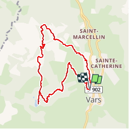

Lengte
8,8 km

Max. hoogte
2142 m

Positief hoogteverschil
551 m
Km-Effort
16,2 km

Min. hoogte
1589 m

Negatief hoogteverschil
557 m
Boucle
Ja
Datum van aanmaak :
2018-04-17 16:54:39.532
Laatste wijziging :
2018-04-17 16:54:39.532
4h00
Moeilijkheid : Medium

Gratisgps-wandelapplicatie
 SityTrail
IGN / Geografische instituten
SityTrail Plus
De wereld gaat voor u open
Over ons
Tocht Sneeuwschoenen van 8,8 km beschikbaar op Provence-Alpes-Côte d'Azur, Hautes-Alpes, Vars. Deze tocht wordt voorgesteld door Michelisabelle.
Plaatsbepaling
Land:
France
Regio :
Provence-Alpes-Côte d'Azur
Departement/Provincie :
Hautes-Alpes
Gemeente :
Vars
Locatie:
Unknown
Vertrek:(Dec)
Vertrek:(UTM)
316544 ; 4940682 (32T) N.
Opmerkingen