


vine 1

colsonandre
Gebruiker
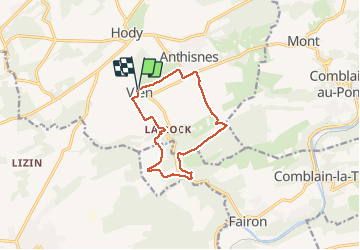

Lengte
10,5 km

Max. hoogte
276 m

Positief hoogteverschil
224 m
Km-Effort
13,5 km

Min. hoogte
158 m

Negatief hoogteverschil
222 m
Boucle
Ja
Datum van aanmaak :
2018-04-17 17:43:36.461
Laatste wijziging :
2020-03-08 18:21:14.029
3h03
Moeilijkheid : Onbekend

Gratisgps-wandelapplicatie
 SityTrail
IGN / Geografische instituten
SityTrail Plus
De wereld gaat voor u open
Over ons
Tocht Stappen van 10,5 km beschikbaar op Wallonië, Luik, Anthisnes. Deze tocht wordt voorgesteld door colsonandre.
Beschrijving
très belle
Plaatsbepaling
Land:
Belgium
Regio :
Wallonië
Departement/Provincie :
Luik
Gemeente :
Anthisnes
Locatie:
Anthisnes
Vertrek:(Dec)
Vertrek:(UTM)
677758 ; 5594340 (31U) N.
Opmerkingen