


Les Deux Chateaux 2

FROIDMONT
Gebruiker

Lengte
10,7 km

Max. hoogte
160 m

Positief hoogteverschil
189 m
Km-Effort
13,2 km

Min. hoogte
82 m

Negatief hoogteverschil
188 m
Boucle
Ja
Datum van aanmaak :
2018-04-17 19:21:06.593
Laatste wijziging :
2018-04-17 19:21:06.593
2h50
Moeilijkheid : Onbekend

Gratisgps-wandelapplicatie
 SityTrail
IGN / Geografische instituten
SityTrail Plus
De wereld gaat voor u open
Over ons
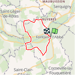
Tocht Stappen van 10,7 km beschikbaar op Normandië, Eure, Fontaine-l'Abbé. Deze tocht wordt voorgesteld door FROIDMONT.
Plaatsbepaling
Land:
France
Regio :
Normandië
Departement/Provincie :
Eure
Gemeente :
Fontaine-l'Abbé
Locatie:
Unknown
Vertrek:(Dec)
Vertrek:(UTM)
331645 ; 5440098 (31U) N.
Opmerkingen