Tocht Paard Saint-André-de-l'Eure - circuit des trois foret - Photo

circuit des trois foret

 thle
thle

Gebruiker

© OpenStreetMap contributors
Lengte
Lengte
22 km
Max. hoogte
Max. hoogte
151 m
Positief hoogteverschil
202 m
Km-Effort
Km-Effort  
25 km
Min. hoogte
Min. hoogte
79 m
Negatief hoogteverschil
202 m
Boucle
Boucle
Ja
Datum van aanmaak :
2018-04-17 19:48:33.523
Laatste wijziging :
2018-04-17 19:48:33.523

(0 Bericht)

Paard
Paard
3h06
Moeilijkheid : Medium

Scan deze QR-code om de tocht te openen in de SityTrail-applicatie

Gratisgps-wandelapplicatie

Logo SityTrail SityTrail

IGN / Geografische instituten

SityTrail uit de App Store downloaden SityTrail uit Google Play downloaden

Logo SityTrail SityTrail Plus

De wereld gaat voor u open

SityTrail uit de App Store downloaden SityTrail uit Google Play downloaden SityTrail op Huawei AppGallery downloaden

Over ons

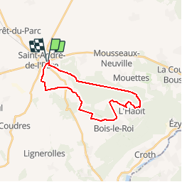
Tocht Paard van 22 km beschikbaar op Normandië, Eure, Saint-André-de-l'Eure. Deze tocht wordt voorgesteld door thle.

Hoogteprofiel

POI's

POI Mousseaux-Neuville - poteau d'orleans - Photo
thle
MOUSSEAUX-NEUVILLE 
POI Saint-André-de-l'Eure - mare de touvoye - Photo
thle
SAINT-ANDRÉ-DE-L'EURE 
POI Saint-André-de-l'Eure - ancienne piste d'envol - Photo
thle
SAINT-ANDRÉ-DE-L'EURE 

Plaatsbepaling

Land:
France
Regio :
Normandië
Departement/Provincie :
Eure
Gemeente :
Saint-André-de-l'Eure
Locatie:
Unknown
Vertrek:(Dec)
Vertrek:(UTM)
373925 ; 5418346 (31U) N.


Sluiten
Mijn abonnementen