


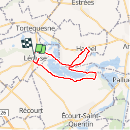
lécluse Hamel par les marais A-R

BRASSENS
Gebruiker

Lengte
10,8 km

Max. hoogte
50 m

Positief hoogteverschil
57 m
Km-Effort
11,6 km

Min. hoogte
33 m

Negatief hoogteverschil
54 m
Boucle
Neen
Datum van aanmaak :
2018-04-17 20:16:08.755
Laatste wijziging :
2018-04-17 20:16:08.755
2h38
Moeilijkheid : Gemakkelijk

Gratisgps-wandelapplicatie
 SityTrail
IGN / Geografische instituten
SityTrail Plus
De wereld gaat voor u open
Over ons
Tocht Stappen van 10,8 km beschikbaar op Hauts-de-France, Noorderdepartement, Lécluse. Deze tocht wordt voorgesteld door BRASSENS.
Plaatsbepaling
Land:
France
Regio :
Hauts-de-France
Departement/Provincie :
Noorderdepartement
Gemeente :
Lécluse
Locatie:
Unknown
Vertrek:(Dec)
Vertrek:(UTM)
502709 ; 5569272 (31U) N.
Opmerkingen