Tocht Stappen Trizay - Marche La maraîchère 2018 - Photo

Marche La maraîchère 2018

 communimage
communimage

Gebruiker

© OpenStreetMap contributors
Lengte
Lengte
9,8 km
Max. hoogte
Max. hoogte
28 m
Positief hoogteverschil
79 m
Km-Effort
Km-Effort  
10,9 km
Min. hoogte
Min. hoogte
-1 m
Negatief hoogteverschil
80 m
Boucle
Boucle
Ja
Datum van aanmaak :
2018-04-18 00:15:44.185
Laatste wijziging :
2018-10-16 18:51:26.08

(0 Bericht)

Stappen
Stappen
2h32
Moeilijkheid : Heel gemakkelijk

Scan deze QR-code om de tocht te openen in de SityTrail-applicatie

Gratisgps-wandelapplicatie

Logo SityTrail SityTrail

IGN / Geografische instituten

SityTrail uit de App Store downloaden SityTrail uit Google Play downloaden

Logo SityTrail SityTrail World

De wereld gaat voor u open

SityTrail uit de App Store downloaden SityTrail uit Google Play downloaden SityTrail op Huawei AppGallery downloaden

Over ons

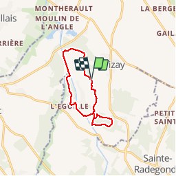
Tocht Stappen van 9,8 km beschikbaar op Nieuw-Aquitanië, Charente-Maritime, Trizay. Deze tocht wordt voorgesteld door communimage.

Hoogteprofiel

Plaatsbepaling

Land:
France
Regio :
Nieuw-Aquitanië
Departement/Provincie :
Charente-Maritime
Gemeente :
Trizay
Locatie:
Unknown
Vertrek:(UTM)
662467 ; 5082498 (30T) N.

Opmerkingen

Gelieve in te loggen om een commentaar of een beoordeling achter te laten


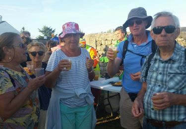
29 mai 2023 - Randonnée faite que partiellement ce jour avec plusieurs problèmes. Des le départ, le tracé tel qu'il est indiqué n'est pas praticable car il traverse une grande serre dont, en fait, il faut faire le tour par la droite. Plus loin, le long du canal de Pont l'abbé, il n'y a plus de chemin, il a été labouré par un agriculteur. Ensuite, après Léguille, il y a une longue traversée d'un bois par un large chemin, puis après plusieurs centaines de mètres, presqu'à la sortie du bois, plus rien, même pas un petit sentier, et donc obligation de faire demi-tour sur tout ce chemin. Voilà mes remarques sur la partie de cette rando que j'ai effectué. C'était certainement une belle rando, mais aujourd'hui le parcours devrait en être modifié.


Wandeltochten in de omgeving

Tocht Fiets Rochefort - Les ponts rochefortais - Rochefort - Photo
Fiets
tracegps

Fiets

Medium
(1)
Rochefort, Nieuw-Aquitanië, Charente-Maritime, France
28 km | 30 km-effort
3h 0min
Ja
Tocht Stappen Rochefort - Rochefort - Photo
Stappen
reva17

Stappen

Gemakkelijk
(1)
Rochefort, Nieuw-Aquitanië, Charente-Maritime, France
10,7 km | 11,7 km-effort
2h 53min
Ja
Tocht Stappen Saint-Agnant - Le long du canal de St Agnant à Echillais - Photo
Stappen
Bobol

Stappen

Gemakkelijk
Saint-Agnant, Nieuw-Aquitanië, Charente-Maritime, France
9,9 km | 10,3 km-effort
2h 6min
Ja
Tocht Stappen Saint-Hippolyte - Hippolyte  - Photo
Stappen
gege92

Stappen

Heel gemakkelijk
Saint-Hippolyte, Nieuw-Aquitanië, Charente-Maritime, France
12,1 km | 13,1 km-effort
3h 40min
Ja
Tocht Stappen Saint-Agnant - st  Aignant - Photo
Stappen
penaud

Stappen

Heel gemakkelijk
Saint-Agnant, Nieuw-Aquitanië, Charente-Maritime, France
12,7 km | 13,7 km-effort
4h 23min
Ja
Tocht Mountainbike Rochefort - Les ponts rochefortais - Rochefort - Photo
Mountainbike
tracegps

Mountainbike

Medium
Rochefort, Nieuw-Aquitanië, Charente-Maritime, France
28 km | 30 km-effort
2h 30min
Ja
Tocht Stappen Rochefort - Les ponts rochefortais - Rochefort - Photo
Stappen
tracegps

Stappen

Moeilijk
Rochefort, Nieuw-Aquitanië, Charente-Maritime, France
28 km | 30 km-effort
5h 0min
Ja
Tocht Stappen Trizay - Randonnée 10kms Trizay - Photo
Stappen
Nadège17170

Stappen

Gemakkelijk
Trizay, Nieuw-Aquitanië, Charente-Maritime, France
10,3 km | 11,1 km-effort
2h 52min
Ja
Tocht Stappen Sainte-Radegonde - Ste-Radégonde (17) - Photo
Stappen
reva17

Stappen

Gemakkelijk
Sainte-Radegonde, Nieuw-Aquitanië, Charente-Maritime, France
11,5 km | 12,9 km-effort
2h 51min
Ja


Sluiten
Mijn abonnementen