


cap blanc jp

NESTOR2714
Gebruiker
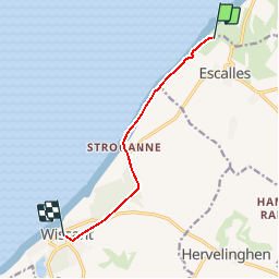

Lengte
6,4 km

Max. hoogte
125 m

Positief hoogteverschil
73 m
Km-Effort
7,7 km

Min. hoogte
6 m

Negatief hoogteverschil
179 m
Boucle
Neen
Datum van aanmaak :
2018-06-26 13:11:32.866
Laatste wijziging :
2018-06-26 13:11:32.866
2h00
Moeilijkheid : Onbekend

Gratisgps-wandelapplicatie
 SityTrail
IGN / Geografische instituten
SityTrail Plus
De wereld gaat voor u open
Over ons
Tocht Andere activiteiten van 6,4 km beschikbaar op Hauts-de-France, Pas-de-Calais, Sangatte. Deze tocht wordt voorgesteld door NESTOR2714.
Beschrijving
cap blanc nez
Plaatsbepaling
Land:
France
Regio :
Hauts-de-France
Departement/Provincie :
Pas-de-Calais
Gemeente :
Sangatte
Locatie:
Unknown
Vertrek:(Dec)
Vertrek:(UTM)
409320 ; 5642272 (31U) N.
Opmerkingen