


Randoguide

rouky
Gebruiker

Lengte
18,1 km

Max. hoogte
287 m

Positief hoogteverschil
455 m
Km-Effort
24 km

Min. hoogte
128 m

Negatief hoogteverschil
453 m
Boucle
Ja
Datum van aanmaak :
2014-12-10 00:00:00.0
Laatste wijziging :
2014-12-10 00:00:00.0
--
Moeilijkheid : Medium

Gratisgps-wandelapplicatie
 SityTrail
IGN / Geografische instituten
SityTrail Plus
De wereld gaat voor u open
Over ons
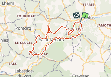
Tocht Stappen van 18,1 km beschikbaar op Occitanië, Lot, Catus. Deze tocht wordt voorgesteld door rouky.
Plaatsbepaling
Land:
France
Regio :
Occitanië
Departement/Provincie :
Lot
Gemeente :
Catus
Locatie:
Unknown
Vertrek:(Dec)
Vertrek:(UTM)
367107 ; 4934567 (31T) N.
Opmerkingen