


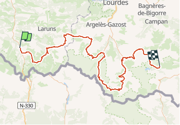
Trace GPS de Borce (Pyrénées-Atlantiques) au Lac de l'Oule (Hautes-Pyrénées)

tigrou31
Gebruiker

Lengte
175 km

Max. hoogte
2738 m

Positief hoogteverschil
11595 m
Km-Effort
326 km

Min. hoogte
595 m

Negatief hoogteverschil
10402 m
Boucle
Neen
Datum van aanmaak :
2018-06-26 13:22:35.5
Laatste wijziging :
2018-06-26 13:22:35.5
61h28
Moeilijkheid : Onbekend

Gratisgps-wandelapplicatie
 SityTrail
IGN / Geografische instituten
SityTrail Plus
De wereld gaat voor u open
Over ons
Tocht Stappen van 175 km beschikbaar op Nieuw-Aquitanië, Pyrénées-Atlantiques, Borce. Deze tocht wordt voorgesteld door tigrou31.
Beschrijving
Trace GPSde Borce (Pyrénées-Atlantiques) au Lac de l'Oule (Hautes-Pyrénées)
Plaatsbepaling
Land:
France
Regio :
Nieuw-Aquitanië
Departement/Provincie :
Pyrénées-Atlantiques
Gemeente :
Borce
Locatie:
Unknown
Vertrek:(Dec)
Vertrek:(UTM)
698053 ; 4753677 (30T) N.
Opmerkingen