


VTT n° 2

dudu85
Gebruiker

Lengte
42 km

Max. hoogte
252 m

Positief hoogteverschil
516 m
Km-Effort
49 km

Min. hoogte
157 m

Negatief hoogteverschil
518 m
Boucle
Ja
Datum van aanmaak :
2018-06-26 15:38:42.274
Laatste wijziging :
2018-06-26 15:38:42.274
3h12
Moeilijkheid : Onbekend

Gratisgps-wandelapplicatie
 SityTrail
IGN / Geografische instituten
SityTrail Plus
De wereld gaat voor u open
Over ons
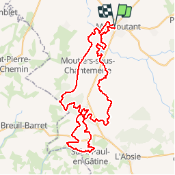
Tocht Mountainbike van 42 km beschikbaar op Nieuw-Aquitanië, Deux-Sèvres, Moncoutant-sur-Sèvre. Deze tocht wordt voorgesteld door dudu85.
Plaatsbepaling
Land:
France
Regio :
Nieuw-Aquitanië
Departement/Provincie :
Deux-Sèvres
Gemeente :
Moncoutant-sur-Sèvre
Locatie:
Unknown
Vertrek:(Dec)
Vertrek:(UTM)
684106 ; 5177227 (30T) N.
Opmerkingen