


ichippe

colsonandre
Gebruiker
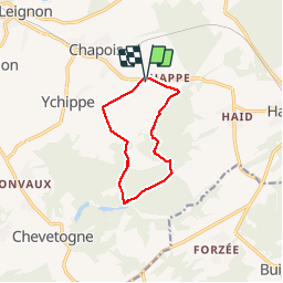

Lengte
8,5 km

Max. hoogte
316 m

Positief hoogteverschil
161 m
Km-Effort
10,7 km

Min. hoogte
237 m

Negatief hoogteverschil
161 m
Boucle
Ja
Datum van aanmaak :
2018-06-26 16:07:18.558
Laatste wijziging :
2019-08-10 15:31:47.607
2h20
Moeilijkheid : Medium

Gratisgps-wandelapplicatie
 SityTrail
IGN / Geografische instituten
SityTrail Plus
De wereld gaat voor u open
Over ons
Tocht Stappen van 8,5 km beschikbaar op Wallonië, Namen, Ciney. Deze tocht wordt voorgesteld door colsonandre.
Plaatsbepaling
Land:
Belgium
Regio :
Wallonië
Departement/Provincie :
Namen
Gemeente :
Ciney
Locatie:
Leignon
Vertrek:(Dec)
Vertrek:(UTM)
653116 ; 5569152 (31U) N.
Opmerkingen