Trail Walking Clécy - CLECY - Photo
© OpenStreetMap contributors
Length
Length
12.7 km
Max alt
Max alt
160 m
Uphill gradient
Uphill gradient
374 m
Km-Effort
Km-Effort  
17.7 km
Min alt
Min alt
33 m
Downhill gradient
Downhill gradient
375 m
Boucle
Boucle
Yes
Creation date :
2015-06-14 00:00:00.0
Updated on :
2021-06-09 21:53:57.793

(1 Reviews)

Walking
Walking
4h01
Difficulty : Difficult
Geocaching
Geocaching
5h20
Difficulty : Difficult

Scan this QR Code to open this trail in the SityTrail application

FREE GPS app for hiking

Logo SityTrail SityTrail

IGN / Geographical institutes

Download SityTrail from the App Store Download SityTrail from Google Play

Logo SityTrail SityTrail World

The world is yours!

Download SityTrail from the App Store Download SityTrail from Google Play Download SityTrail on Huawei AppGallery

About

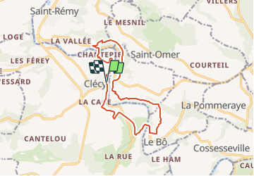
Trail Walking of 12.7 km to be discovered at Normandy, Calvados, Clécy. This trail is proposed by yannick-p.

Description

Nouveauté 2021 : Le parcours comprend 34 caches, dont 1 cache mystère (la Bonus), 1 multicache et 1 earthcache.

🌻🦅1 @ Clecy - Départ 🧗🚶
🌻🦅 2@ Clecy - Placy 🧗🚶
🌻🦅 6@ Clecy - Suisse Normande 🧗🚶-
🌻🦅 12 @ Clecy - Le Moulin du Vey 🧗🚶
🌻🦅 13 @ Clecy - La Voie SNCF 🧗🚶

Caches supplémentaires :

🌻🦅 6 bis @ Clecy - Suisse Normande 🧗🚶
🌻🦅 10 bis @ Clecy - GR 36 🧗🚶
🌻🦅 11 bis @ Clecy - Le Physicien 🧗🚶

Une petite earthcache au passage, en cours d'examen :

27 @ Clecy 🌍 La barre des Rochers des Parcs 🌍

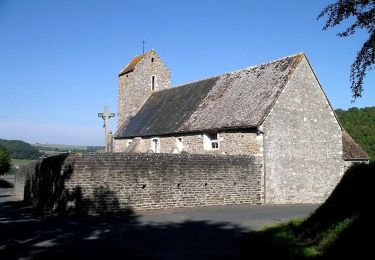
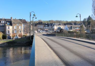
Clécy - Suisse Normande

Clécy est située sur l'Orne, au cœur de la Suisse normande, à 35 kilomètres au sud de Caen. Couvrant 2 463 hectares, le territoire communal est le plus étendu du canton de Thury-Harcourt.

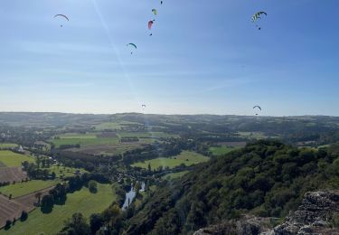
Titré Capitale de la Suisse normande, ce village doit son renom au relief accidenté et verdoyant du massif armoricain, avec des gorges dans lesquelles circule l'Orne.

De nombreuses activités de plein air s'y développent : canoë-kayak, parapente, escalade, randonnées pédestres et VTT... profitant ainsi de la typicité géologique de la Suisse normande.

Bonnes recherches et bonnes découvertes !!!

Elevation profile

Photos

Positioning

Country:
France
Region :
Normandy
Department/Province :
Calvados
Municipality :
Clécy
Location:
Unknown
Start:(UTM)
684878 ; 5421235 (30U) N.

Comments

Please log in to post a review or rate the element


Trails nearby

Trail Mountain bike Saint-Omer - Espace VTT FFC de Suisse Normande - Circuit 11 - Saint Omer - Photo
Mountain bike
tracegps

Mountain bike

Very difficult
(1)
Saint-Omer, Normandy, Calvados, France
25 km | 34 km-effort
3h 0min
Yes
Trail Walking Le Vey - Clécy - Photo
Walking
zefreefly

Walking

Easy
Le Vey, Normandy, Calvados, France
14.8 km | 20 km-effort
3h 51min
Yes
Trail On foot Culey-le-Patry - Le Mouin du Fay - Photo
On foot
PRO

On foot

Easy
Culey-le-Patry, Normandy, Calvados, France
4.8 km | 6.7 km-effort
1h 31min
No
Trail On foot Le Bô - Des Montagnes de Normandie? - Photo
On foot
PRO

On foot

Medium
Le Bô, Normandy, Calvados, France
15.4 km | 20 km-effort
4h 38min
No
Trail On foot Esson - La Chapelle Bonne Nouvelle - Photo
On foot
PRO

On foot

Easy
Esson, Normandy, Calvados, France
9.5 km | 13.3 km-effort
3h 1min
Yes
Trail On foot La Pommeraye - Les Rochers de Briesvieille - Photo
On foot
PRO

On foot

Easy
La Pommeraye, Normandy, Calvados, France
9.1 km | 12.9 km-effort
2h 55min
No
Trail On foot Le Bô - Le Moulin à Papier - Photo
On foot
PRO

On foot

Easy
Le Bô, Normandy, Calvados, France
7.1 km | 9.6 km-effort
2h 11min
Yes
Trail On foot Esson - GRP Tour de la Suisse Normande - Photo
On foot
PRO

On foot

Difficult
Esson, Normandy, Calvados, France
25 km | 35 km-effort
7h 58min
No
Trail Mountain bike Saint-Rémy - VTT Suisse Normande N°10 - St Rémy sur Orne - Photo
Mountain bike
tracegps

Mountain bike

Easy
Saint-Rémy, Normandy, Calvados, France
15.8 km | 20 km-effort
1h 30min
Yes


Close
My subscriptions