


Sortie 12-02-2017

malc
User
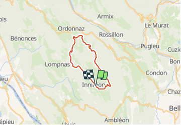

Length
18.6 km

Max alt
1158 m

Uphill gradient
536 m
Km-Effort
26 km

Min alt
852 m

Downhill gradient
535 m
Boucle
Yes
Creation date :
2017-02-12 00:00:00.0
Updated on :
2017-02-12 00:00:00.0
1h53
Difficulty : Medium

FREE GPS app for hiking
 SityTrail
IGN / Geographical institutes
SityTrail Plus
The world is yours!
About
Trail Mountain bike of 18.6 km to be discovered at Auvergne-Rhône-Alpes, Ain, Innimond. This trail is proposed by malc.
Positioning
Country:
France
Region :
Auvergne-Rhône-Alpes
Department/Province :
Ain
Municipality :
Innimond
Location:
Unknown
Start:(Dec)
Start:(UTM)
700014 ; 5073073 (31T) N.
Comments