Randonnée Course à pied Stavelot - Stavelot_9km - Photo
 florkin
florkin

Utilisateur

© OpenStreetMap contributors
Longueur
Longueur
9,9 km
Altitude max
Altitude max
511 m
Dénivelé positif
Dénivelé positif
276 m
Km-Effort
Km-Effort  
13,6 km
Altitude min
Altitude min
281 m
Dénivelé négatif
Dénivelé négatif
274 m
Boucle
Boucle
Oui
Date de création :
2016-06-12 00:00:00.0
Dernière modification :
2016-06-12 00:00:00.0

(2 Avis)

Course à pied
Course à pied
1h00
Difficulté : Facile

Scannez ce code QR pour ouvrir la randonnée dans l'application SityTrail

Application GPS de randonnée GRATUITE

Logo SityTrail SityTrail

IGN / Instituts géographiques

Télécharger SityTrail sur l'App Store Télécharger SityTrail sur Google Play

Logo SityTrail SityTrail World

Le monde est à vous

Télécharger SityTrail sur l'App Store Télécharger SityTrail sur Google Play Télécharger SityTrail sur Huawei AppGallery

À propos

Randonnée Course à pied de 9,9 km à découvrir à Wallonie, Liège, Stavelot. Cette randonnée est proposée par florkin.

Profil altimétrique

Localisation

Pays :
Belgique
Région :
Wallonie
Département/Province :
Liège
Commune :
Stavelot
Localité :
Stavelot
Départ:(Dec)
Départ:(UTM)
708379 ; 5586514 (31U) N.

Commentaires

Veuillez vous connecter pour laisser un commentaire ou une note


Mooie toch, maar wel veel ongelijke oppervlakte...maar dat was juist leuk. Helaas een paar stukken verhard. Verder goed aangegeven.


Randonnées à proximité

Randonnée Marche Trois-Ponts - RB-Lg-29_Wanne - Photo
Marche
PRO

Marche

Très difficile
(5)
Trois-Ponts, Wallonie, Liège, Belgique
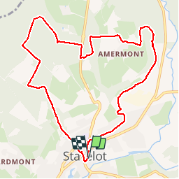
22 km | 29 km-effort
6h 9min
Oui
Randonnée Marche Trois-Ponts - RB-Lg-27_Trois-Ponts - Photo
Marche
PRO

Marche

Très difficile
(7)
Trois-Ponts, Wallonie, Liège, Belgique
23 km | 33 km-effort
6h 58min
Oui
Randonnée Marche Stavelot - Extratrail_stavelot_13km_new - Photo
Marche
GUIDE
mumu.larandonneuse

Marche

Moyen
(2)
Stavelot, Wallonie, Liège, Belgique
13,4 km | 19,8 km-effort
4h 30min
Oui
Randonnée Marche Stavelot - Stavelot  - Photo
Marche
GUIDE
mumu.larandonneuse

Marche

Difficile
(3)
Stavelot, Wallonie, Liège, Belgique
18,8 km | 26 km-effort
5h 53min
Non
Randonnée Marche Trois-Ponts - RB-Lg-29_Wanne_via-racc-2 - Photo
Marche
PRO

Marche

Très difficile
(3)
Trois-Ponts, Wallonie, Liège, Belgique
14,2 km | 19,2 km-effort
4h 21min
Oui
Randonnée Marche Trois-Ponts - RB-Lg-27_Trois-Ponts_via-racc - Photo
Marche
PRO

Marche

Très difficile
(1)
Trois-Ponts, Wallonie, Liège, Belgique
17 km | 25 km-effort
5h 12min
Oui
Randonnée Marche Stavelot - Chemin des Sources |étape n°3  STAVELOT – HOCKAI - Photo
Marche
PRO

Marche

Très difficile
(1)
Stavelot, Wallonie, Liège, Belgique
19 km | 25 km-effort
5h 45min
Non
Randonnée Trail Stavelot - Extra Trail - Stavelot (rouge) 23km - Photo
Trail
PRO

Trail

Très difficile
(1)
Stavelot, Wallonie, Liège, Belgique
23 km | 35 km-effort
Inconnu
Oui
Randonnée Trail Stavelot - Extra Trail - Stavelot (bleu) 13km - Photo
Trail
PRO

Trail

Difficile
(1)
Stavelot, Wallonie, Liège, Belgique
13,4 km | 19,5 km-effort
Inconnu
Oui


Fermer
Mes abonnements