Trail Winter sports Orsières - La Fouly, Ski de fond, La Fouly , 10 km - Photo

La Fouly, Ski de fond, La Fouly , 10 km

 verbier
verbier

User

© OpenStreetMap contributors
Length
Length
9.2 km
Max alt
Max alt
1690 m
Uphill gradient
Uphill gradient
219 m
Km-Effort
Km-Effort  
12.1 km
Min alt
Min alt
1539 m
Downhill gradient
Downhill gradient
218 m
Boucle
Boucle
Yes
Creation date :
2014-12-10 00:00:00.0
Updated on :
2014-12-10 00:00:00.0

(0 Reviews)

Winter sports
Winter sports
1h00
Difficulty : Unknown

Scan this QR Code to open this trail in the SityTrail application

FREE GPS app for hiking

Logo SityTrail SityTrail

IGN / Geographical institutes

Download SityTrail from the App Store Download SityTrail from Google Play

Logo SityTrail SityTrail World

The world is yours!

Download SityTrail from the App Store Download SityTrail from Google Play Download SityTrail on Huawei AppGallery

About

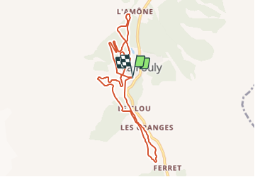
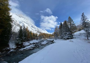
Trail Winter sports of 9.2 km to be discovered at Valais/Wallis, Entremont, Orsières. This trail is proposed by verbier.

Description

Réputée pour sa splendide piste de fond, La Fouly ravit les amateurs de ski de fond classique ou de skating. La piste accueille régulièrement des compétitions nationales et internationales et propose plusieurs variantes d’itinéraires. Vallonnée et étendue, elle s’étend de l’Amône à Ferret, le long de la Dranse.

Elevation profile

Points of interest

Point of interest Orsières - Arrêt bus La Fouly - Photo
verbier
Point of interest Orsières - Parking - Photo
verbier
ORSIÈRES 
Point of interest Orsières - Départ - Photo
verbier
ORSIÈRES 

Positioning

Country:
Switzerland
Region :
Valais/Wallis
Department/Province :
Entremont
Municipality :
Orsières
Location:
Unknown
Start:(UTM)
352453 ; 5088165 (32T) N.

Trails nearby

Trail On foot Orsières - Trail Verbier St-Bernard - Traversée - Photo
On foot
PRO

On foot

Very difficult
Orsières, Valais/Wallis, Entremont, Switzerland
37 km | 70 km-effort
15h 47min
No
Trail On foot Orsières - Sentier des Bergers - Photo
On foot
PRO

On foot

Easy
Orsières, Valais/Wallis, Entremont, Switzerland
4.8 km | 9.2 km-effort
2h 5min
No
Trail On foot Courmayeur - Itinerario 23 Rifugio Dalmazzi - Photo
On foot
PRO

On foot

Easy
Courmayeur, Aosta Valley, Unknown, Italy
4.1 km | 6.6 km-effort
1h 29min
No
Trail Walking Orsières - La Fouly, Randonée hivernale, Sentier de l''Amône  - Photo
Walking
verbier

Walking

Very easy
(1)
Orsières, Valais/Wallis, Entremont, Switzerland
1.9 km | 2.7 km-effort
50min
Yes
Trail Walking Orsières - ferret La Foully - Photo
Walking
michauxpaul

Walking

Medium
Orsières, Valais/Wallis, Entremont, Switzerland
4.6 km | 6.1 km-effort
2h 20min
No
Trail Walking Orsières - fully  - Photo
Walking
suzanne.bron

Walking

Easy
Orsières, Valais/Wallis, Entremont, Switzerland
3.8 km | 4.9 km-effort
1h 19min
No
Trail Walking Orsières - TMB J3 La FOULY - Ref. ELENA - Photo
Walking
GerardBouche

Walking

Difficult
Orsières, Valais/Wallis, Entremont, Switzerland
10.3 km | 23 km-effort
4h 46min
No
Trail Walking Orsières - Cabane de l''A Neuve - Photo
Walking
verbier

Walking

Very easy
Orsières, Valais/Wallis, Entremont, Switzerland
5.4 km | 16.6 km-effort
2h 43min
No
Trail Walking Orsières - w_CHpur05_lafouly - Photo
Walking
GUIDE+

Walking

Very easy
Orsières, Valais/Wallis, Entremont, Switzerland
15.4 km | 30 km-effort
Unknown
Yes


Close
My subscriptions