Home
World
NEW
Premium
Shop
Trails
Articles
Help and support
Français
English
Nederlands
Español
Italiano
Deutsch
Log in
Home
World
Premium
Shop
Trails
Articles
Help and support
SityTrail
>
Points of interest
>
GCH6K9
SityTrail
>
Points of interest
>
GCH6K9
GCH6K9
Description
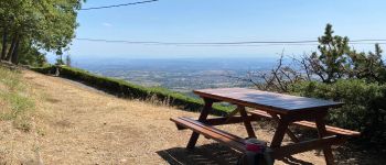
Le Signal by Lou & Isa, Tradit
Photos
GCH6K9 can be discovered in the following trails...
tracegps
Col du Souffre et Lacs Mont-Coua
Walking
Difficult
(1)
Les Allues, Auvergne-Rhône-Alpes, Savoy, France
25 km | 41 km-effort
7h 0min
Yes
tracegps
User
©
OpenStreetMap
contributors
Positioning
Country:
France
Region :
Auvergne-Rhône-Alpes
Department/Province :
Rhône
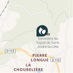
Municipality :
Saint-André-la-Côte
Location:
Unknown
Positioning
45.63719999 / 4.592366964
Creation date :
2018-04-09 12:22:18.396
Updated on
2018-04-09 12:22:18.396
(0 Reviews)
Comments
Please log in to post a review or rate the element
Points of interest nearby
tracegps
GCH6K9
SAINT-ANDRÉ-LA-CÔTE
tracegps
GCH6K9
SAINT-ANDRÉ-LA-CÔTE
tracegps
GCH6K9
SAINT-ANDRÉ-LA-CÔTE
tracegps
GCH6K9
SAINT-ANDRÉ-LA-CÔTE
tracegps
GCH6K9
SAINT-ANDRÉ-LA-CÔTE
philippe2434
Point 1
SAINT-ANDRÉ-LA-CÔTE
philippe2434
Point 2
SAINT-ANDRÉ-LA-CÔTE
galain
Unnamed POI
SAINT-ANDRÉ-LA-CÔTE
Close
My subscriptions