Home
World
NEW
Premium
Shop
Trails
Articles
Help and support
Français
English
Nederlands
Español
Italiano
Deutsch
Log in
Home
World
Premium
Shop
Trails
Articles
Help and support
SityTrail
>
Points of interest
>
GC14MG2
SityTrail
>
Points of interest
>
GC14MG2
GC14MG2
Description
LE LAC CACHE by joerpick, Unkn
Photos
GC14MG2 can be discovered in the following trails...
tracegps
Dent du Villard depuis La Rosière
Walking
Difficult
(1)
Courchevel, Auvergne-Rhône-Alpes, Savoy, France
9.4 km | 19.2 km-effort
6h 0min
Yes
tracegps
User
©
OpenStreetMap
contributors
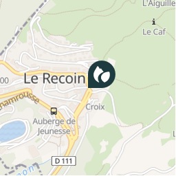
Positioning
Country:
France
Region :
Auvergne-Rhône-Alpes
Department/Province :
Isère
Municipality :
Chamrousse
Location:
Unknown
Positioning
45.125767 / 5.879083
Creation date :
2018-04-09 12:16:57.887
Updated on
2018-04-09 12:16:57.887
(0 Reviews)
Comments
Please log in to post a review or rate the element
Points of interest nearby
tracegps
GC14MG2
CHAMROUSSE
tracegps
GC14MG2
CHAMROUSSE
tracegps
GC14MG2
CHAMROUSSE
tracegps
GC14MG2
CHAMROUSSE
tracegps
GC14MG2
CHAMROUSSE
tracegps
GC14MG2
CHAMROUSSE
tracegps
GC14MG2
CHAMROUSSE
tracegps
GC14MG2
CHAMROUSSE
Close
My subscriptions