Trail Walking Saiguède - Raide de Saiguède - Photo
 tracegps
tracegps

User

© OpenStreetMap contributors
Length
Length
19 km
Max alt
Max alt
322 m
Uphill gradient
Uphill gradient
279 m
Km-Effort
Km-Effort  
23 km
Min alt
Min alt
228 m
Downhill gradient
Downhill gradient
279 m
Boucle
Boucle
Yes
Creation date :
2014-12-10 00:00:00.0
Updated on :
2014-12-10 00:00:00.0

(1 Reviews)

Walking
Walking
4h00
Difficulty : Difficult

Scan this QR Code to open this trail in the SityTrail application

FREE GPS app for hiking

Logo SityTrail SityTrail

IGN / Geographical institutes

Download SityTrail from the App Store Download SityTrail from Google Play

Logo SityTrail SityTrail World

The world is yours!

Download SityTrail from the App Store Download SityTrail from Google Play Download SityTrail on Huawei AppGallery

About

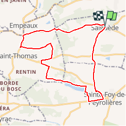
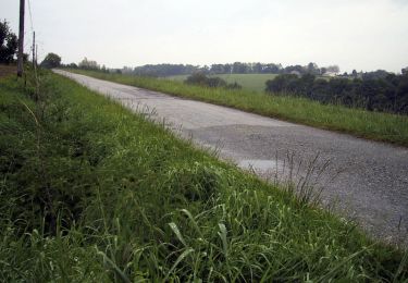
Trail Walking of 19 km to be discovered at Occitania, Haute-Garonne, Saiguède. This trail is proposed by tracegps.

Description

Saiguède, en Saves, est située sur la ligne de crête de partage des eaux entre la Save et la Garonne, à 25 km à l'ouest de Toulouse. Dès le départ, on grimpe .... pendant 4 km sur 100 m de dénivelé. Après 7,5 km, à Larroudé, joli chemin de 1 km. Puis, à 14 km, on longe le Lac de Minjoulet, dans les faubourgs de Ste Foy de Peyrolières, avant de revenir en montée et en descente sur Saiguède.

Elevation profile

Photos

Positioning

Country:
France
Region :
Occitania
Department/Province :
Haute-Garonne
Municipality :
Saiguède
Location:
Unknown
Start:(UTM)
350086 ; 4821237 (31T) N.

Comments

Please log in to post a review or rate the element


Trails nearby

Trail Walking Sainte-Foy-de-Peyrolières - RANDO-Ste Foy Téléthon 2012 - Photo
Walking
Polo-31

Walking

Easy
Sainte-Foy-de-Peyrolières, Occitania, Haute-Garonne, France
8 km | 9.3 km-effort
2h 2min
Yes
Trail Walking Sainte-Foy-de-Peyrolières - Lac et bois autour de Sainte Foy de Peyrolières - Photo
Walking
tracegps

Walking

Easy
Sainte-Foy-de-Peyrolières, Occitania, Haute-Garonne, France
9 km | 11.2 km-effort
2h 30min
Yes
Trail Walking Sainte-Foy-de-Peyrolières - Ste Foy de Peyrolières 13 Avril 2020 - Photo
Walking
daniel3157

Walking

Easy
Sainte-Foy-de-Peyrolières, Occitania, Haute-Garonne, France
16.4 km | 21 km-effort
4h 58min
Yes
Trail Running Fontenilles - Fontenilles à Lias - Photo
Running
tracegps

Running

Difficult
Fontenilles, Occitania, Haute-Garonne, France
13.7 km | 16.4 km-effort
1h 19min
Yes
Trail Mountain bike Fontenilles - Fontenilles à Lias - Photo
Mountain bike
tracegps

Mountain bike

Medium
Fontenilles, Occitania, Haute-Garonne, France
13.7 km | 16.4 km-effort
1h 0min
Yes
Trail Running Fontenilles - De Fontenilles à Saiguède - Photo
Running
tracegps

Running

Difficult
Fontenilles, Occitania, Haute-Garonne, France
16.2 km | 19.5 km-effort
1h 30min
Yes
Trail Running Saiguède - Raide de Saiguède - Photo
Running
tracegps

Running

Very difficult
Saiguède, Occitania, Haute-Garonne, France
19 km | 23 km-effort
2h 0min
Yes
Trail Walking Sainte-Foy-de-Peyrolières - Randonnée Sainte Foy de Peyrolières  - Photo
Walking
Fafou64

Walking

Sainte-Foy-de-Peyrolières, Occitania, Haute-Garonne, France
10.7 km | 12.9 km-effort
2h 39min
Yes
Trail Walking Saiguède - Saiguède belles vues - Photo
Walking
pidjam

Walking

Very easy
Saiguède, Occitania, Haute-Garonne, France
8.3 km | 10.5 km-effort
2h 0min
Yes


Close
My subscriptions