Trail Mountain bike Grendelbruch - Grendelbruch: Genêts, Digitales et Signal - Photo

Grendelbruch: Genêts, Digitales et Signal

 tracegps
tracegps

User

© OpenStreetMap contributors
Length
Length
36 km
Max alt
Max alt
983 m
Uphill gradient
Uphill gradient
1181 m
Km-Effort
Km-Effort  
52 km
Min alt
Min alt
317 m
Downhill gradient
Downhill gradient
1179 m
Boucle
Boucle
Yes
Creation date :
2014-12-10 00:00:00.0
Updated on :
2014-12-10 00:00:00.0

(0 Reviews)

Mountain bike
Mountain bike
4h00
Difficulty : Difficult

Scan this QR Code to open this trail in the SityTrail application

FREE GPS app for hiking

Logo SityTrail SityTrail

IGN / Geographical institutes

Download SityTrail from the App Store Download SityTrail from Google Play

Logo SityTrail SityTrail World

The world is yours!

Download SityTrail from the App Store Download SityTrail from Google Play Download SityTrail on Huawei AppGallery

About

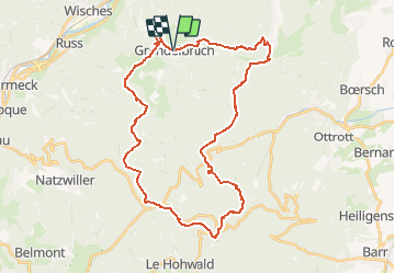
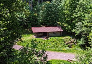
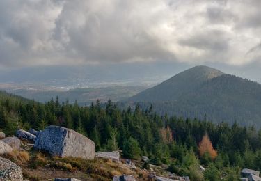
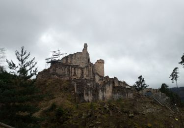
Trail Mountain bike of 36 km to be discovered at Grand Est, Bas-Rhin, Grendelbruch. This trail is proposed by tracegps.

Description

Ce circuit offre un échauffement progressif par le Guirbaden. La montée vers le Champ du Messin est longue par rapport au temps passé à descendre sur Grendelbruch. Autour du Signal il faut profiter, suivant la saison, de la floraison des genêts et des digitales qui tapissent les environs.

Elevation profile

Photos

Positioning

Country:
France
Region :
Grand Est
Department/Province :
Bas-Rhin
Municipality :
Grendelbruch
Location:
Unknown
Start:(UTM)
376092 ; 5372397 (32U) N.

Trails nearby

Trail Walking Urmatt - Cascade Soultzbach - Urmatt - Photo
Walking
Mich&Agnès

Walking

Very difficult
(1)
Urmatt, Grand Est, Bas-Rhin, France
14.9 km | 21 km-effort
4h 46min
Yes
Trail Walking Ottrott - Montée vers le Mont Sainte-Odile - Photo
Walking
VacheKiri67

Walking

Difficult
(1)
Ottrott, Grand Est, Bas-Rhin, France
17.6 km | 26 km-effort
5h 52min
Yes
Trail Walking Lutzelhouse - suuntoapp-Hiking-2024-01-28T11-41-12Z - Photo
Walking
GUIDE
holtzv

Walking

Medium
Lutzelhouse, Grand Est, Bas-Rhin, France
15.3 km | 25 km-effort
5h 45min
Yes
Trail Walking Grendelbruch - suuntoapp-Hiking-2024-01-21T12-04-41Z - Photo
Walking
GUIDE
holtzv

Walking

Easy
Grendelbruch, Grand Est, Bas-Rhin, France
12.1 km | 19.3 km-effort
4h 23min
Yes
Trail Horseback riding Mollkirch - 2023-05-28 Picnic CVA Cabane des 5 routes - Photo
Horseback riding
GUIDE
holtzv

Horseback riding

Medium
Mollkirch, Grand Est, Bas-Rhin, France
36 km | 51 km-effort
6h 39min
Yes
Trail Walking Lutzelhouse - 2019-11-30 Marche Rocher de Mutzig Noll - Photo
Walking
GUIDE
holtzv

Walking

Very easy
Lutzelhouse, Grand Est, Bas-Rhin, France
18.7 km | 29 km-effort
4h 39min
Yes
Trail Equestrian Rosheim - 2013-05-12 Picnic CVA Maennelstein - Photo
Equestrian
GUIDE
holtzv

Equestrian

Medium
(1)
Rosheim, Grand Est, Bas-Rhin, France
29 km | 41 km-effort
2h 33min
Yes
Trail Horseback riding Grendelbruch - Boucle Grendelbruch Schirmeck - Photo
Horseback riding
GUIDE+

Horseback riding

Difficult
Grendelbruch, Grand Est, Bas-Rhin, France
27 km | 41 km-effort
5h 20min
Yes
Trail Walking Ottrott - 2023-02-18 Vorbruck - Mt st Odile - Photo
Walking
Mich&Agnès

Walking

Medium
Ottrott, Grand Est, Bas-Rhin, France
14.3 km | 23 km-effort
3h 18min
Yes


Close
My subscriptions