Trail Mountain bike Bagnères-de-Luchon - Luchonnais Vallée d'Oueil - Photo

Luchonnais Vallée d'Oueil

 tracegps
tracegps

User

© OpenStreetMap contributors
Length
Length
48 km
Max alt
Max alt
1980 m
Uphill gradient
Uphill gradient
1953 m
Km-Effort
Km-Effort  
74 km
Min alt
Min alt
623 m
Downhill gradient
Downhill gradient
1953 m
Boucle
Boucle
Yes
Creation date :
2014-12-10 00:00:00.0
Updated on :
2014-12-10 00:00:00.0

(0 Reviews)

Mountain bike
Mountain bike
6h30
Difficulty : Very difficult

Scan this QR Code to open this trail in the SityTrail application

FREE GPS app for hiking

Logo SityTrail SityTrail

IGN / Geographical institutes

Download SityTrail from the App Store Download SityTrail from Google Play

Logo SityTrail SityTrail World

The world is yours!

Download SityTrail from the App Store Download SityTrail from Google Play Download SityTrail on Huawei AppGallery

About

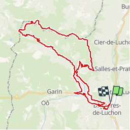
Trail Mountain bike of 48 km to be discovered at Occitania, Haute-Garonne, Bagnères-de-Luchon. This trail is proposed by tracegps.

Description

26 Mai 2006 Après prise de rdv pour co-voiturage partiel (je suis déjà pas loin), on se retrouve au rond point à la sortie de la bretelle d'autoroute où on charge tout dans le Scénic. Direction la gare de Luchon. Premiers tours de manivelle vers 9h40 locales (le fichier GPS donne l'heure en temps universel soit 2h de décalage). La montée commence par la portion de route du col de Peyresourde. La suite est ICI Source: Jfd

Elevation profile

Photos

Positioning

Country:
France
Region :
Occitania
Department/Province :
Haute-Garonne
Municipality :
Bagnères-de-Luchon
Location:
Unknown
Start:(UTM)
303410 ; 4741145 (31T) N.

Trails nearby

Trail Snowshoes Juzet-de-Luchon - JUZET - PAS DE LA COMBE (LABACH) - Photo
Snowshoes
Marcocroco

Snowshoes

Medium
(1)
Juzet-de-Luchon, Occitania, Haute-Garonne, France
7.1 km | 12.5 km-effort
2h 33min
Yes
Trail Walking Saint-Mamet - Fonds de Burbe - Saint Mamet - Photo
Walking
tracegps

Walking

Difficult
(1)
Saint-Mamet, Occitania, Haute-Garonne, France
15.6 km | 27 km-effort
4h 0min
Yes
Trail Mountain bike Saint-Aventin - Luchon Kbour - Photo
Mountain bike
tracegps

Mountain bike

Very difficult
(1)
Saint-Aventin, Occitania, Haute-Garonne, France
11 km | 16.7 km-effort
1h 0min
No
Trail Walking Saccourvielle - Cap de Salières en boucle depuis Saccourvielle - Photo
Walking
GUIDE
lhomme.ph

Walking

Medium
Saccourvielle, Occitania, Haute-Garonne, France
12.1 km | 24 km-effort
6h 23min
Yes
Trail Walking Bagnères-de-Luchon - GR 10 - 3 - Photo
Walking
loic09

Walking

Medium
(2)
Bagnères-de-Luchon, Occitania, Haute-Garonne, France
250 km | 489 km-effort
89h 8min
No
Trail Walking Artigue - ARTIGUE - Gouaux de Luchon - chemin forestier - Photo
Walking
josy31

Walking

Medium
(1)
Artigue, Occitania, Haute-Garonne, France
13.7 km | 23 km-effort
3h 21min
Yes
Trail Walking Saint-Aventin - Cabane de Courreau en boucle depuis St Aventin  - Photo
Walking
GUIDE
lhomme.ph

Walking

Medium
Saint-Aventin, Occitania, Haute-Garonne, France
13.3 km | 24 km-effort
6h 10min
Yes
Trail Walking Artigue - Artigue par la cabane du plan Bosc et la cabane de Saunères - Photo
Walking
swp648

Walking

Difficult
Artigue, Occitania, Haute-Garonne, France
10.5 km | 18.3 km-effort
4h 10min
Yes
Trail Walking Bagnères-de-Luchon - 2022 08 -Transpyrénéen 2 : Bagnères de Luchon -Fos - Photo
Walking
LEGUE

Walking

Very difficult
Bagnères-de-Luchon, Occitania, Haute-Garonne, France
30 km | 55 km-effort
7h 8min
No


Close
My subscriptions