Trail Mountain bike Vielle-Adour - Bagnères-de-Bigorre - Col du couret - Photo

Bagnères-de-Bigorre - Col du couret

 tracegps
tracegps

User

© OpenStreetMap contributors
Length
Length
47 km
Max alt
Max alt
1228 m
Uphill gradient
Uphill gradient
1026 m
Km-Effort
Km-Effort  
61 km
Min alt
Min alt
415 m
Downhill gradient
Downhill gradient
1026 m
Boucle
Boucle
Yes
Creation date :
2014-12-10 00:00:00.0
Updated on :
2014-12-10 00:00:00.0

(0 Reviews)

Mountain bike
Mountain bike
3h15
Difficulty : Difficult

Scan this QR Code to open this trail in the SityTrail application

FREE GPS app for hiking

Logo SityTrail SityTrail

IGN / Geographical institutes

Download SityTrail from the App Store Download SityTrail from Google Play

Logo SityTrail SityTrail World

The world is yours!

Download SityTrail from the App Store Download SityTrail from Google Play Download SityTrail on Huawei AppGallery

About

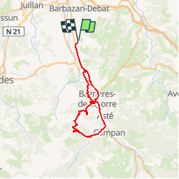
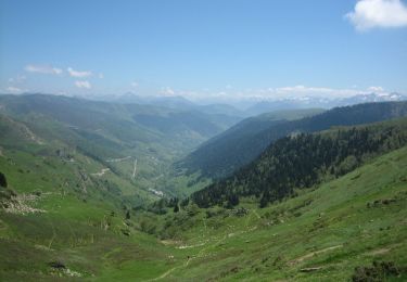
Trail Mountain bike of 47 km to be discovered at Occitania, Hautespyrenees, Vielle-Adour. This trail is proposed by tracegps.

Description

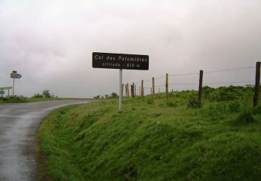
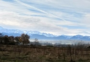
28 Mars 2005 La semaine prochaine : la Cordiolo, 55kms pour 1400m . Sur le papier c'est prometteur, au moins, niveau dénivelé ! Il me faut donc m'entraîner en grimpette : Le col de Couret fera l'affaire. 10 kms de montée pour environ 1000m  : c'est pas mal ! La suite est ICI

Elevation profile

Positioning

Country:
France
Region :
Occitania
Department/Province :
Hautespyrenees
Municipality :
Vielle-Adour
Location:
Unknown
Start:(UTM)
265485 ; 4781311 (31T) N.

Trails nearby

Trail Walking Montgaillard - montgaillard G2 - Photo
Walking
LouisROGER

Walking

Very easy
(1)
Montgaillard, Occitania, Hautespyrenees, France
10.4 km | 14.2 km-effort
3h 0min
Yes
Trail Mountain bike Vielle-Adour - Autour de Bagnères-de-bigorre - Photo
Mountain bike
tracegps

Mountain bike

Difficult
Vielle-Adour, Occitania, Hautespyrenees, France
39 km | 51 km-effort
3h 15min
Yes
Trail Mountain bike Vielle-Adour - Bagnères-de-Bigorre - Montgaillard - Photo
Mountain bike
tracegps

Mountain bike

Medium
Vielle-Adour, Occitania, Hautespyrenees, France
38 km | 48 km-effort
3h 0min
Yes
Trail Walking Bernac-Debat - bernac les deux fait - Photo
Walking
LouisROGER

Walking

Very easy
Bernac-Debat, Occitania, Hautespyrenees, France
7.8 km | 9.2 km-effort
2h 40min
Yes
Trail Nordic walking Montgaillard - montgaillard brouillon - Photo
Nordic walking
GIRAUDEL

Nordic walking

Easy
Montgaillard, Occitania, Hautespyrenees, France
6.9 km | 9 km-effort
1h 38min
Yes
Trail Nordic walking Horgues - Horgues Odos - Photo
Nordic walking
GIRAUDEL

Nordic walking

Easy
Horgues, Occitania, Hautespyrenees, France
9.1 km | 9.8 km-effort
2h 3min
Yes
Trail Mountain bike Montgaillard - Espace VTT FFC Haute Bigorre - Circuit n° 14 - Les Puyolles - Photo
Mountain bike
tracegps

Mountain bike

Medium
Montgaillard, Occitania, Hautespyrenees, France
6.7 km | 8.7 km-effort
1h 0min
Yes
Trail Mountain bike Montgaillard - Espace VTT FFC Haute Bigorre - Circuit n° 13 - Le Bois d'Antist - Photo
Mountain bike
tracegps

Mountain bike

Medium
Montgaillard, Occitania, Hautespyrenees, France
11 km | 13.5 km-effort
1h 30min
Yes
Trail Mountain bike Vielle-Adour - Bagnères, Couret, Hourc, Chiroulet - Photo
Mountain bike
tracegps

Mountain bike

Very difficult
Vielle-Adour, Occitania, Hautespyrenees, France
59 km | 78 km-effort
3h 30min
Yes


Close
My subscriptions