Trail Mountain bike Mollkirch - Circuit du Hahnenberg - Photo

Circuit du Hahnenberg

 tracegps
tracegps

User

© OpenStreetMap contributors
Length
Length
19.4 km
Max alt
Max alt
606 m
Uphill gradient
Uphill gradient
772 m
Km-Effort
Km-Effort  
30 km
Min alt
Min alt
214 m
Downhill gradient
Downhill gradient
771 m
Boucle
Boucle
Yes
Creation date :
2014-12-10 00:00:00.0
Updated on :
2014-12-10 00:00:00.0

(0 Reviews)

Mountain bike
Mountain bike
1h30
Difficulty : Difficult

Scan this QR Code to open this trail in the SityTrail application

FREE GPS app for hiking

Logo SityTrail SityTrail

IGN / Geographical institutes

Download SityTrail from the App Store Download SityTrail from Google Play

Logo SityTrail SityTrail World

The world is yours!

Download SityTrail from the App Store Download SityTrail from Google Play Download SityTrail on Huawei AppGallery

About

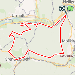
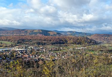
Trail Mountain bike of 19.4 km to be discovered at Grand Est, Bas-Rhin, Mollkirch. This trail is proposed by tracegps.

Description

Suivez le sentier chevalet bleu jusqu'à la M.F. Hirschbaechler.C'est un sentier légèrement vallonné , idéal pour l'échauffement. Contournez la M.F. par la droite et commencez l'ascension par le sentier rectangle jaune. Certaines portions de ce sentier sont très raides , mais techniquement pas très difficiles car le chemin est carrossable. Au sommet , faites une pause et appréciez la vue. La suite ICI

Elevation profile

Photos

Positioning

Country:
France
Region :
Grand Est
Department/Province :
Bas-Rhin
Municipality :
Mollkirch
Location:
Unknown
Start:(UTM)
380522 ; 5376182 (32U) N.

Trails nearby

Trail Walking Urmatt - Cascade Soultzbach - Urmatt - Photo
Walking
Mich&Agnès

Walking

Very difficult
(1)
Urmatt, Grand Est, Bas-Rhin, France
14.9 km | 21 km-effort
4h 46min
Yes
Trail Walking Mutzig - Autour du Fort de Mutzig - Photo
Walking
VacheKiri67

Walking

Difficult
(2)
Mutzig, Grand Est, Bas-Rhin, France
18.7 km | 26 km-effort
6h 30min
Yes
Trail Horseback riding Oberhaslach - Neufeld Boucle Elmersforst - Photo
Horseback riding
GUIDE
holtzv

Horseback riding

Difficult
(1)
Oberhaslach, Grand Est, Bas-Rhin, France
31 km | 42 km-effort
5h 9min
Yes
Trail Mountain bike Niederhaslach - Guirbaden - Grendelbruch - Photo
Mountain bike
tracegps

Mountain bike

Difficult
(1)
Niederhaslach, Grand Est, Bas-Rhin, France
26 km | 35 km-effort
2h 30min
No
Trail Mountain bike Dinsheim-sur-Bruche - Les Grandes Manoeuvres - Photo
Mountain bike
tracegps

Mountain bike

Very difficult
(1)
Dinsheim-sur-Bruche, Grand Est, Bas-Rhin, France
45 km | 59 km-effort
4h 0min
Yes
Trail Mountain bike Oberhaslach - Rando des Feuilles Mortes - Photo
Mountain bike
tracegps

Mountain bike

Medium
(1)
Oberhaslach, Grand Est, Bas-Rhin, France
29 km | 41 km-effort
2h 0min
Yes
Trail Horseback riding Gresswiller - 2023-11-19 Picnic CVA Les pelouses du Jesselsberg - Photo
Horseback riding
GUIDE
holtzv

Horseback riding

Easy
Gresswiller, Grand Est, Bas-Rhin, France
28 km | 36 km-effort
4h 45min
Yes
Trail Horseback riding Niederhaslach - Toutes fugues  - Photo
Horseback riding
feelou

Horseback riding

Easy
(1)
Niederhaslach, Grand Est, Bas-Rhin, France
29 km | 39 km-effort
Unknown
Yes
Trail Horseback riding Mollkirch - 2023-05-28 Picnic CVA Cabane des 5 routes - Photo
Horseback riding
GUIDE
holtzv

Horseback riding

Medium
Mollkirch, Grand Est, Bas-Rhin, France
36 km | 51 km-effort
6h 39min
Yes


Close
My subscriptions