Trail Mountain bike Rosheim - Boucle à Rosenwiller - Photo

Boucle à Rosenwiller

 tracegps
tracegps

User

© OpenStreetMap contributors
Length
Length
12.1 km
Max alt
Max alt
394 m
Uphill gradient
Uphill gradient
312 m
Km-Effort
Km-Effort  
16.3 km
Min alt
Min alt
201 m
Downhill gradient
Downhill gradient
315 m
Boucle
Boucle
Yes
Creation date :
2014-12-10 00:00:00.0
Updated on :
2014-12-10 00:00:00.0

(0 Reviews)

Mountain bike
Mountain bike
1h00
Difficulty : Medium

Scan this QR Code to open this trail in the SityTrail application

FREE GPS app for hiking

Logo SityTrail SityTrail

IGN / Geographical institutes

Download SityTrail from the App Store Download SityTrail from Google Play

Logo SityTrail SityTrail World

The world is yours!

Download SityTrail from the App Store Download SityTrail from Google Play Download SityTrail on Huawei AppGallery

About

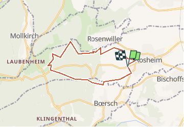
Trail Mountain bike of 12.1 km to be discovered at Grand Est, Bas-Rhin, Rosheim. This trail is proposed by tracegps.

Description

Le balisage du circuit est relativement bien fait. Si vous ne voyez pas de balise à un carrefour, suivez le chemin le plus usité devant vous. Vous pouvez démarrer de Rosenwiller ( à la sortie du village vers le cimetière ) ou de Rosheim. Ce circuit, principalement en forêt, vous fera passer près de la M.F. de l'Eichwald, Rosheim et les vignobles aux alentours de Boersch et Rosenwiller. Ce circuit n'est pas difficile. La suite ICI

Elevation profile

Photos

Positioning

Country:
France
Region :
Grand Est
Department/Province :
Bas-Rhin
Municipality :
Rosheim
Location:
Unknown
Start:(Dec)
Start:(UTM)
385919 ; 5372260 (32U) N.

Trails nearby

Trail Walking Mutzig - Les sanctuaires autour de Mutzig - Photo
Walking
VacheKiri67

Walking

Medium
(1)
Mutzig, Grand Est, Bas-Rhin, France
13.6 km | 17.9 km-effort
5h 0min
Yes
Trail Walking Ottrott - Le Mont Sainte-Odile depuis Otrott - Photo
Walking
VacheKiri67

Walking

Medium
(1)
Ottrott, Grand Est, Bas-Rhin, France
13 km | 20 km-effort
6h 18min
Yes
Trail Walking Mutzig - Les sanctuaires autour de Mutzig - Photo
Walking
tracegps

Walking

Difficult
(1)
Mutzig, Grand Est, Bas-Rhin, France
12.7 km | 16.8 km-effort
4h 0min
Yes
Trail Walking Dorlisheim - Escapade dans le vignoble de Dorlisheim - Photo
Walking
tracegps

Walking

Medium
(1)
Dorlisheim, Grand Est, Bas-Rhin, France
9.7 km | 12.6 km-effort
3h 0min
Yes
Trail Walking Mutzig - Autour du Fort de Mutzig - Photo
Walking
VacheKiri67

Walking

Difficult
(2)
Mutzig, Grand Est, Bas-Rhin, France
18.7 km | 26 km-effort
6h 30min
Yes
Trail Walking Obernai - Obernai gare - Mont St Odile - Photo
Walking
tracegps

Walking

Difficult
(2)
Obernai, Grand Est, Bas-Rhin, France
20 km | 29 km-effort
5h 0min
Yes
Trail Mountain bike Ottrott - Sainte-Odile East-Face - Photo
Mountain bike
tracegps

Mountain bike

Difficult
(1)
Ottrott, Grand Est, Bas-Rhin, France
24 km | 39 km-effort
3h 0min
Yes
Trail Horseback riding Gresswiller - 2023-11-19 Picnic CVA Les pelouses du Jesselsberg - Photo
Horseback riding
GUIDE
holtzv

Horseback riding

Easy
Gresswiller, Grand Est, Bas-Rhin, France
28 km | 36 km-effort
4h 45min
Yes
Trail Horseback riding Gresswiller - 2022-11-06 Picnic CVA Neuntelstein - Photo
Horseback riding
GUIDE
holtzv

Horseback riding

Medium
Gresswiller, Grand Est, Bas-Rhin, France
36 km | 50 km-effort
6h 28min
Yes


Close
My subscriptions