Trail Mountain bike Orbey - Les Balcons d'Orbey - Photo

Les Balcons d'Orbey

 tracegps
tracegps

User

© OpenStreetMap contributors
Length
Length
37 km
Max alt
Max alt
1130 m
Uphill gradient
Uphill gradient
1134 m
Km-Effort
Km-Effort  
52 km
Min alt
Min alt
462 m
Downhill gradient
Downhill gradient
1137 m
Boucle
Boucle
Yes
Creation date :
2014-12-10 00:00:00.0
Updated on :
2014-12-10 00:00:00.0

(0 Reviews)

Mountain bike
Mountain bike
3h30
Difficulty : Very difficult

Scan this QR Code to open this trail in the SityTrail application

FREE GPS app for hiking

Logo SityTrail SityTrail

IGN / Geographical institutes

Download SityTrail from the App Store Download SityTrail from Google Play

Logo SityTrail SityTrail World

The world is yours!

Download SityTrail from the App Store Download SityTrail from Google Play Download SityTrail on Huawei AppGallery

About

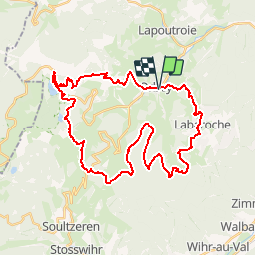
Trail Mountain bike of 37 km to be discovered at Grand Est, Haut-Rhin, Orbey. This trail is proposed by tracegps.

Description

Le topo joint n'est là qu'à titre d'information.Le balisage à partir d'Orbey est très bien fait , il n'y a donc pas lieu d'utiliser une carte. Le circuit démarre au niveau de l'église sur du macadam pendant environ 2 kms.La montée vers le lac Blanc est émaillée de quelques passages techniques dans le sable et/ou la pierraille. La partie entre les 2 lacs peut se faire soit par la route , soit en suivant les balises en sachant que dans le deuxième cas , il faudra compter avec du portage. A partir du lac Noir , le circuit est vallonné et vous conduira à Labaroche par le col du Wettstein et le mémorial du Linge. Le chemin est toujours large et ne présente pas de difficultés techniques. La descente vers Orbey se fait sur macadam principalement et permet " de se laisser aller ". D'autres infos et une carte sont dispo ICI

Elevation profile

Photos

Positioning

Country:
France
Region :
Grand Est
Department/Province :
Haut-Rhin
Municipality :
Orbey
Location:
Unknown
Start:(UTM)
363441 ; 5331947 (32U) N.

Trails nearby

Trail Horseback riding Orbey - 2020-06-28 WE Orbey Petit Hohnack Glasborn - Photo
Horseback riding
GUIDE
holtzv

Horseback riding

Difficult
(1)
Orbey, Grand Est, Haut-Rhin, France
22 km | 31 km-effort
4h 5min
Yes
Trail Horseback riding Orbey - 2020-06-27 WE Orbey Noir Gazon Vert Forlet - Photo
Horseback riding
GUIDE
holtzv

Horseback riding

Medium
(1)
Orbey, Grand Est, Haut-Rhin, France
21 km | 30 km-effort
3h 59min
Yes
Trail Walking Ammerschwihr - Trois Épis le rocher du corbeau  - Photo
Walking
zazie

Walking

Easy
(2)
Ammerschwihr, Grand Est, Haut-Rhin, France
4.4 km | 5.7 km-effort
59min
Yes
Trail Mountain bike Labaroche - Tour de Labaroche - Photo
Mountain bike
tracegps

Mountain bike

Medium
(1)
Labaroche, Grand Est, Haut-Rhin, France
23 km | 31 km-effort
3h 30min
Yes
Trail Walking Lapoutroie - 2012-06-16 Marche aux Alisiers Orbey - Photo
Walking
GUIDE
holtzv

Walking

Easy
(2)
Lapoutroie, Grand Est, Haut-Rhin, France
11.1 km | 16.6 km-effort
2h 49min
Yes
Trail Horseback riding Orbey - gite pre au bois gazon du Faing lac blanc lac noir - Photo
Horseback riding
IsaFal

Horseback riding

Medium
(1)
Orbey, Grand Est, Haut-Rhin, France
17.2 km | 25 km-effort
3h 17min
Yes
Trail Walking Lapoutroie - 2020-07-19 Marche Étang du Devin Col Calvaire Tête des Faux - Photo
Walking
GUIDE
holtzv

Walking

Very easy
Lapoutroie, Grand Est, Haut-Rhin, France
14.2 km | 22 km-effort
3h 27min
Yes
Trail Walking Orbey - PR- Lac B&N-6Km - Photo
Walking
JMCMoreau

Walking

Medium
(1)
Orbey, Grand Est, Haut-Rhin, France
5.5 km | 9.7 km-effort
3h 0min
Yes
Trail Walking Orbey - Orbey-Labaroche - Photo
Walking
ilur56

Walking

Easy
(1)
Orbey, Grand Est, Haut-Rhin, France
13.7 km | 21 km-effort
4h 17min
Yes


Close
My subscriptions