Trail Mountain bike Lyon - Tête d'Or - Miribel - Photo
 tracegps
tracegps

User

© OpenStreetMap contributors
Length
Length
26 km
Max alt
Max alt
188 m
Uphill gradient
Uphill gradient
184 m
Km-Effort
Km-Effort  
29 km
Min alt
Min alt
166 m
Downhill gradient
Downhill gradient
184 m
Boucle
Boucle
No
Creation date :
2014-12-10 00:00:00.0
Updated on :
2014-12-10 00:00:00.0

(0 Reviews)

Mountain bike
Mountain bike
1h45
Difficulty : Medium

Scan this QR Code to open this trail in the SityTrail application

FREE GPS app for hiking

Logo SityTrail SityTrail

IGN / Geographical institutes

Download SityTrail from the App Store Download SityTrail from Google Play

Logo SityTrail SityTrail World

The world is yours!

Download SityTrail from the App Store Download SityTrail from Google Play Download SityTrail on Huawei AppGallery

About

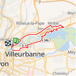
Trail Mountain bike of 26 km to be discovered at Auvergne-Rhône-Alpes, Métropole de Lyon, Lyon. This trail is proposed by tracegps.

Description

Tracé simple et à plat avec un départ/retour au parc de la Tête d'Or et totalement sur piste ou voie cyclable protégée. La première partie le long de la voie ferrée est caillouteuse, puis un passage dans Miribel en empruntant les chemins balisés 5 puis 2. Enfin un retour par la piste cyclable jusqu'au parc. On peut sans soucis emmener des enfants à VTT, prévoir un peu plus de temps et pourquoi pas une pause au parc de Miribel.

Elevation profile

Positioning

Country:
France
Region :
Auvergne-Rhône-Alpes
Department/Province :
Métropole de Lyon
Municipality :
Lyon
Location:
Lyon 6e Arrondissement
Start:(UTM)
644374 ; 5071773 (31T) N.

Trails nearby

Trail Mountain bike Collonges-au-Mont-d'Or - Tour du Mont Cindre et Mont Thoux - Photo
Mountain bike
tracegps

Mountain bike

Difficult
(3)
Collonges-au-Mont-d'Or, Auvergne-Rhône-Alpes, Métropole de Lyon, France
25 km | 33 km-effort
1h 40min
Yes
Trail Mountain bike Lyon - Mont Verdun - Photo
Mountain bike
tracegps

Mountain bike

Difficult
(2)
Lyon, Auvergne-Rhône-Alpes, Métropole de Lyon, France
29 km | 37 km-effort
2h 15min
Yes
Trail Walking Lyon - De Place des Archives à Monplaisir - Photo
Walking
Marie-Hélène Luton 2

Walking

Difficult
(1)
Lyon, Auvergne-Rhône-Alpes, Métropole de Lyon, France
11.2 km | 12.9 km-effort
2h 55min
No
Trail Walking Caluire-et-Cuire - A_CALUIRE 69300 St-Clair - Crépieux - Photo
Walking
ANDREJAC

Walking

Easy
(1)
Caluire-et-Cuire, Auvergne-Rhône-Alpes, Métropole de Lyon, France
10 km | 11.7 km-effort
3h 0min
Yes
Trail Mountain bike Lyon - Monts d'Or_02 - Photo
Mountain bike
philmascio

Mountain bike

Medium
(2)
Lyon, Auvergne-Rhône-Alpes, Métropole de Lyon, France
32 km | 45 km-effort
2h 54min
Yes
Trail Walking Saint-Cyr-au-Mont-d'Or - s3-c_st_cyr_69450_3d_homme_paysage - Photo
Walking
vidal.galaxy

Walking

Medium
(1)
Saint-Cyr-au-Mont-d'Or, Auvergne-Rhône-Alpes, Métropole de Lyon, France
6.6 km | 9.3 km-effort
2h 6min
Yes
Trail Walking Sainte-Foy-lès-Lyon - Sainte foy les lyon - Photo
Walking
daniellebou

Walking

Difficult
(1)
Sainte-Foy-lès-Lyon, Auvergne-Rhône-Alpes, Métropole de Lyon, France
9.9 km | 13.2 km-effort
2h 52min
Yes
Trail Walking Lyon - Fnac - Photo
Walking
ricoux

Walking

Easy
(1)
Lyon, Auvergne-Rhône-Alpes, Métropole de Lyon, France
1.9 km | 2.3 km-effort
18min
No
Trail Walking Lyon - cuire et ile barbe - Photo
Walking
maclobar

Walking

Very difficult
Lyon, Auvergne-Rhône-Alpes, Métropole de Lyon, France
17.8 km | 23 km-effort
5h 16min
No


Close
My subscriptions