Trail Mountain bike Manosque - Autour de Manosque - Col de la Mort d'Imbert - Photo

Autour de Manosque - Col de la Mort d'Imbert

 tracegps
tracegps

User

© OpenStreetMap contributors
Length
Length
29 km
Max alt
Max alt
763 m
Uphill gradient
Uphill gradient
899 m
Km-Effort
Km-Effort  
41 km
Min alt
Min alt
369 m
Downhill gradient
Downhill gradient
894 m
Boucle
Boucle
Yes
Creation date :
2014-12-10 00:00:00.0
Updated on :
2014-12-10 00:00:00.0

(0 Reviews)

Mountain bike
Mountain bike
3h30
Difficulty : Very difficult

Scan this QR Code to open this trail in the SityTrail application

FREE GPS app for hiking

Logo SityTrail SityTrail

IGN / Geographical institutes

Download SityTrail from the App Store Download SityTrail from Google Play

Logo SityTrail SityTrail World

The world is yours!

Download SityTrail from the App Store Download SityTrail from Google Play Download SityTrail on Huawei AppGallery

About

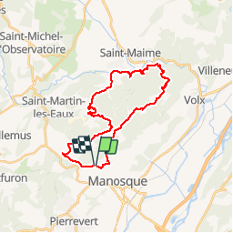
Trail Mountain bike of 29 km to be discovered at Provence-Alpes-Côte d'Azur, Alpes-de-Haute-Provence, Manosque. This trail is proposed by tracegps.

Description

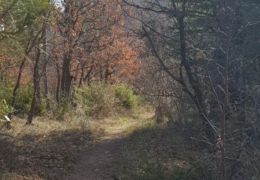
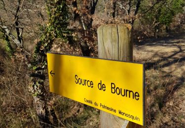
Autour de Manosque – La Thomassine – Col de la Mort d’Imbert – Forêt domaniale de Pélissier. Descente jusqu’à St Maime et remontée par Bellevue vers le col d’Imbert pour revenir à Manosque.

Elevation profile

Positioning

Country:
France
Region :
Provence-Alpes-Côte d'Azur
Department/Province :
Alpes-de-Haute-Provence
Municipality :
Manosque
Location:
Unknown
Start:(UTM)
722370 ; 4858043 (31T) N.

Trails nearby

Trail Walking Manosque - Le Val des Chats, avant le col de la Mort d'Imbert. - Photo
Walking
liocol

Walking

Easy
(2)
Manosque, Provence-Alpes-Côte d'Azur, Alpes-de-Haute-Provence, France
4.7 km | 6.5 km-effort
1h 23min
Yes
Trail Walking Manosque - Le tour de la borie '' pain de sucre ''  - Photo
Walking
PITOUSSAINT

Walking

Easy
(1)
Manosque, Provence-Alpes-Côte d'Azur, Alpes-de-Haute-Provence, France
5.1 km | 7.4 km-effort
1h 43min
Yes
Trail Walking Manosque - Quartier des Espels, départ Piscine. - Photo
Walking
liocol

Walking

Easy
(1)
Manosque, Provence-Alpes-Côte d'Azur, Alpes-de-Haute-Provence, France
4.8 km | 7.3 km-effort
1h 50min
Yes
Trail Walking Manosque - MANOSQUE VOLX PAR LES COLLINES O S - Photo
Walking
RobinMicheline

Walking

Difficult
Manosque, Provence-Alpes-Côte d'Azur, Alpes-de-Haute-Provence, France
17.7 km | 24 km-effort
4h 15min
Yes
Trail Walking Manosque - 1Les speels, le relais, le pain de sucre. Depart Crématoriome. - Photo
Walking
liocol

Walking

Medium
(1)
Manosque, Provence-Alpes-Côte d'Azur, Alpes-de-Haute-Provence, France
6.1 km | 9.7 km-effort
2h 4min
Yes
Trail Walking Saint-Martin-les-Eaux - 1Domaine de Bourne - Photo
Walking
liocol

Walking

Medium
Saint-Martin-les-Eaux, Provence-Alpes-Côte d'Azur, Alpes-de-Haute-Provence, France
5.6 km | 8.3 km-effort
2h 2min
Yes
Trail Walking Manosque - 1Gaude, boucle de Montaigu.  - Photo
Walking
liocol

Walking

Medium
Manosque, Provence-Alpes-Côte d'Azur, Alpes-de-Haute-Provence, France
6.6 km | 10.2 km-effort
2h 7min
Yes
Trail Walking Manosque - 1Pélicier, chemin des collines, le Chateau via l'Ausselet - Photo
Walking
liocol

Walking

Easy
Manosque, Provence-Alpes-Côte d'Azur, Alpes-de-Haute-Provence, France
7.1 km | 9.7 km-effort
2h 9min
Yes
Trail Walking Manosque - 1La maison bleue, source de Bourne et dalle aux empreintes - Photo
Walking
liocol

Walking

Medium
Manosque, Provence-Alpes-Côte d'Azur, Alpes-de-Haute-Provence, France
7.4 km | 11.2 km-effort
2h 30min
Yes


Close
My subscriptions