Trail Mountain bike Savournon - Grande Traversée des PréAlpes à VTT : Les Arnauds (Savouron) - Arzeliers - Photo

Grande Traversée des PréAlpes à VTT : Les Arnauds (Savouron) - Arzeliers

 tracegps
tracegps

User

© OpenStreetMap contributors
Length
Length
22 km
Max alt
Max alt
1060 m
Uphill gradient
Uphill gradient
651 m
Km-Effort
Km-Effort  
30 km
Min alt
Min alt
644 m
Downhill gradient
Downhill gradient
729 m
Boucle
Boucle
No
Creation date :
2014-12-10 00:00:00.0
Updated on :
2014-12-10 00:00:00.0

(0 Reviews)

Mountain bike
Mountain bike
2h30
Difficulty : Difficult

Scan this QR Code to open this trail in the SityTrail application

FREE GPS app for hiking

Logo SityTrail SityTrail

IGN / Geographical institutes

Download SityTrail from the App Store Download SityTrail from Google Play

Logo SityTrail SityTrail World

The world is yours!

Download SityTrail from the App Store Download SityTrail from Google Play Download SityTrail on Huawei AppGallery

About

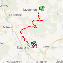
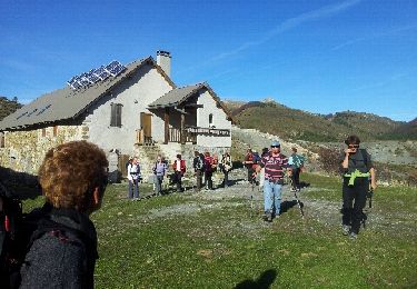
Trail Mountain bike of 22 km to be discovered at Provence-Alpes-Côte d'Azur, Hautes-Alpes, Savournon. This trail is proposed by tracegps.

Description

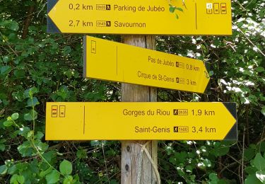
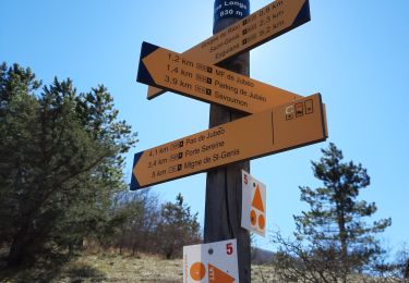
Grande Traversée des Préalpes, les Chemins du Soleil. Parcours officiel labellisé par la Fédération Française de Cyclisme. Parcours Valence – Gap - Sisteron – Tronçon n° 35 Niveau: moyen avec une montée très raide avant les ruines d'Eyguians. Mesure de prudence: descente rapide avec de grosses ornières après les ruines de Ville-Vieille. Consultez toutes les informations sur les hébergements et les services associés sur la fiche du tronçon. Retrouvez cette traversée dans l’indispensable topo Guide Chamina Grande Traversée des Préalpes
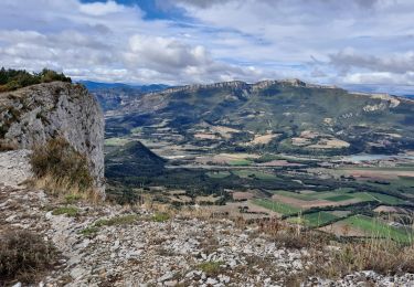
Elevation profile

Photos

Positioning

Country:
France
Region :
Provence-Alpes-Côte d'Azur
Department/Province :
Hautes-Alpes
Municipality :
Savournon
Location:
Unknown
Start:(UTM)
724124 ; 4921678 (31T) N.

Trails nearby

Trail Walking Le Saix - R36 - Aujour depuis Clausonne - Photo
Walking
GUIDE+

Walking

Difficult
Le Saix, Provence-Alpes-Côte d'Azur, Hautes-Alpes, France
11.9 km | 22 km-effort
4h 27min
Yes
Trail Walking Garde-Colombe - R33   La Montagne de Saint Genis - Photo
Walking
GUIDE+

Walking

Medium
Garde-Colombe, Provence-Alpes-Côte d'Azur, Hautes-Alpes, France
11.4 km | 19.4 km-effort
3h 59min
Yes
Trail Walking Savournon - Reco Jubeo + 250 - Photo
Walking
claude nier

Walking

Medium
Savournon, Provence-Alpes-Côte d'Azur, Hautes-Alpes, France
10 km | 13.3 km-effort
3h 4min
Yes
Trail On foot Garde-Colombe - Revuaire - Photo
On foot
Marco05

On foot

Difficult
Garde-Colombe, Provence-Alpes-Côte d'Azur, Hautes-Alpes, France
12.1 km | 21 km-effort
4h 42min
Yes
Trail Walking Garde-Colombe - Le réduire.. gorge du riou - Photo
Walking
gibello

Walking

Medium
Garde-Colombe, Provence-Alpes-Côte d'Azur, Hautes-Alpes, France
12.1 km | 21 km-effort
5h 3min
Yes
Trail Walking Ventavon - montagne de Peyssier - Photo
Walking
BLANCHET

Walking

Easy
(1)
Ventavon, Provence-Alpes-Côte d'Azur, Hautes-Alpes, France
13.6 km | 24 km-effort
5h 2min
Yes
Trail Walking Garde-Colombe - Plan d’eau de St Genis  - Photo
Walking
Pierrannick

Walking

Easy
Garde-Colombe, Provence-Alpes-Côte d'Azur, Hautes-Alpes, France
4.2 km | 5.2 km-effort
1h 37min
No
Trail Walking Ventavon - VENTAVON  lac de Peysier n - Photo
Walking
RobinMicheline

Walking

Medium
Ventavon, Provence-Alpes-Côte d'Azur, Hautes-Alpes, France
9.3 km | 16.7 km-effort
2h 53min
Yes
Trail Walking Ventavon - VENTAVON  . crête de Colombier , roc de l Escubier o m s  - Photo
Walking
RobinMicheline

Walking

Difficult
Ventavon, Provence-Alpes-Côte d'Azur, Hautes-Alpes, France
12 km | 21 km-effort
4h 11min
Yes


Close
My subscriptions