Trail Mountain bike Argences - Argences - Photo
 tracegps
tracegps

User

© OpenStreetMap contributors
Length
Length
31 km
Max alt
Max alt
76 m
Uphill gradient
Uphill gradient
358 m
Km-Effort
Km-Effort  
36 km
Min alt
Min alt
12 m
Downhill gradient
Downhill gradient
356 m
Boucle
Boucle
Yes
Creation date :
2014-12-10 00:00:00.0
Updated on :
2014-12-10 00:00:00.0

(0 Reviews)

Mountain bike
Mountain bike
2h30
Difficulty : Medium

Scan this QR Code to open this trail in the SityTrail application

FREE GPS app for hiking

Logo SityTrail SityTrail

IGN / Geographical institutes

Download SityTrail from the App Store Download SityTrail from Google Play

Logo SityTrail SityTrail World

The world is yours!

Download SityTrail from the App Store Download SityTrail from Google Play Download SityTrail on Huawei AppGallery

About

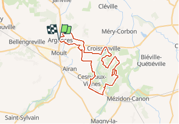
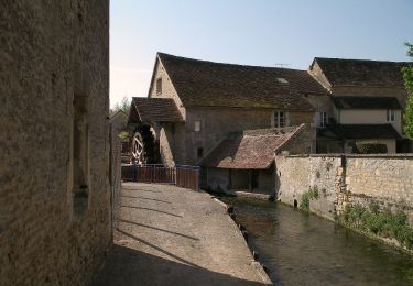
Trail Mountain bike of 31 km to be discovered at Normandy, Calvados, Argences. This trail is proposed by tracegps.

Description

Une petite rando bien sympa avec une bonne partie en sous bois. Vraiment très sympa, à part 2 ou 3 kilomètres de plaine, le reste c'est que du bonheur ! Vous êtes encore dans le pays où "il fait beau plusieurs fois par jour"... Donc il est plutôt à faire par temps sec sinon vous aurez quelques passages gras qu'il faudra contourner en portant le vélo. Bonne promenade !

Elevation profile

Positioning

Country:
France
Region :
Normandy
Department/Province :
Calvados
Municipality :
Argences
Location:
Unknown
Start:(UTM)
706847 ; 5445392 (30U) N.

Trails nearby

Trail Walking Saint-Ouen-du-Mesnil-Oger - st ouen du mesnil oger - Photo
Walking
nono1425

Walking

Very easy
(1)
Saint-Ouen-du-Mesnil-Oger, Normandy, Calvados, France
5.1 km | 5.5 km-effort
1h 20min
No
Trail Nordic walking Moult-Chicheboville - 41b_les_eoliennes-6844076-1676016099-46 - Photo
Nordic walking
phi14

Nordic walking

Very easy
(1)
Moult-Chicheboville, Normandy, Calvados, France
8.6 km | 9.4 km-effort
Unknown
Yes
Trail Nordic walking Moult-Chicheboville - 2b_moult_bois_saint_gilles-11832667-1675352732-615 - Photo
Nordic walking
phi14

Nordic walking

Very easy
(1)
Moult-Chicheboville, Normandy, Calvados, France
8.7 km | 10 km-effort
Unknown
Yes
Trail On foot Argences - Les Crêtes d'Argences - Photo
On foot
PRO

On foot

Easy
Argences, Normandy, Calvados, France
6 km | 7.1 km-effort
1h 37min
Yes
Trail On foot Argences - Les Sentes de l'Avant Côte d'Auge - Photo
On foot
PRO

On foot

Easy
Argences, Normandy, Calvados, France
4.5 km | 5.3 km-effort
1h 12min
No
Trail On foot Argences - Vignes et Bruyères - Photo
On foot
PRO

On foot

Easy
Argences, Normandy, Calvados, France
15.9 km | 17.8 km-effort
4h 2min
Yes
Trail On foot Méry-Bissières-en-Auge - Vignes et Pommiers - Photo
On foot
PRO

On foot

Easy
Méry-Bissières-en-Auge, Normandy, Calvados, France
9.5 km | 10.8 km-effort
2h 27min
Yes
Trail On foot Valambray - Bois, Vignes, Champs et Prés - Photo
On foot
PRO

On foot

Medium
Valambray, Normandy, Calvados, France
20 km | 23 km-effort
5h 15min
Yes
Trail On foot Valambray - La Tour de Valmeray et la Muance - Photo
On foot
PRO

On foot

Easy
Valambray, Normandy, Calvados, France
11.7 km | 12.7 km-effort
2h 53min
Yes


Close
My subscriptions