Trail Walking Pleudihen-sur-Rance - 19/08/2018 - De Mordreuc nord à  La Vicomté à Coëtquen.Virtuel.  - Photo

19/08/2018 - De Mordreuc nord à La Vicomté à Coëtquen.Virtuel.

 babeth35
babeth35

User

© OpenStreetMap contributors
Length
Length
41 km
Max alt
Max alt
71 m
Uphill gradient
Uphill gradient
510 m
Km-Effort
Km-Effort  
48 km
Min alt
Min alt
3 m
Downhill gradient
Downhill gradient
507 m
Boucle
Boucle
Yes
Creation date :
2019-01-16 09:49:24.696
Updated on :
2020-07-20 15:03:47.252

(0 Reviews)

Walking
Walking
10h26
Difficulty : Medium

Scan this QR Code to open this trail in the SityTrail application

FREE GPS app for hiking

Logo SityTrail SityTrail

IGN / Geographical institutes

Download SityTrail from the App Store Download SityTrail from Google Play

Logo SityTrail SityTrail World

The world is yours!

Download SityTrail from the App Store Download SityTrail from Google Play Download SityTrail on Huawei AppGallery

About

Trail Walking of 41 km to be discovered at Brittany, Côtes-d'Armor, Pleudihen-sur-Rance. This trail is proposed by babeth35.

Elevation profile

Photos

Points of interest

Point of interest Pleudihen-sur-Rance - Chapelle Ste Honorine - Photo
babeth35
PLEUDIHEN-SUR-RANCE 
Point of interest La Vicomté-sur-Rance - Moulin du Prat - Photo
babeth35
LA VICOMTÉ-SUR-RANCE 
Point of interest Pleudihen-sur-Rance - Moulin de Mordreuc - Photo
babeth35
PLEUDIHEN-SUR-RANCE 
Point of interest Pleudihen-sur-Rance - Plage de la Ville Ger - Photo
babeth35
PLEUDIHEN-SUR-RANCE 
Point of interest Pleudihen-sur-Rance - Depuis la Cale de Mordreuc - Photo
babeth35
PLEUDIHEN-SUR-RANCE 
Point of interest Saint-Hélen - Chateau de Coëtquen - Photo
babeth35
SAINT-HÉLEN 
Point of interest La Vicomté-sur-Rance - Les Carrelets - Photo
babeth35
LA VICOMTÉ-SUR-RANCE 
Point of interest La Vicomté-sur-Rance - Pont du Lessard - Photo
babeth35
LA VICOMTÉ-SUR-RANCE 
Point of interest Plouër-sur-Rance - En face, le moulin de Rochefort - Photo
babeth35

Positioning

Country:
France
Region :
Brittany
Department/Province :
Côtes-d'Armor
Municipality :
Pleudihen-sur-Rance
Location:
Unknown
Start:(UTM)
576460 ; 5375260 (30U) N.

Trails nearby

Trail Mountain bike Plouër-sur-Rance - Vallée de la Rance par Plouer sur Rance et Dinan - Photo
Mountain bike
tracegps

Mountain bike

Medium
(1)
Plouër-sur-Rance, Brittany, Côtes-d'Armor, France
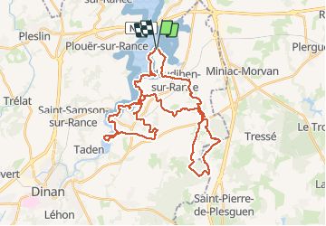
27 km | 33 km-effort
2h 30min
Yes
Trail Walking Saint-Suliac - Saint-Suliac les bords de la Rance - Photo
Walking
zefreefly

Walking

Very easy
Saint-Suliac, Brittany, Ille-et-Vilaine, France
20 km | 24 km-effort
4h 54min
Yes
Trail Walking Saint-Suliac - Petite boucle autour de Saint Suliac J6 - Photo
Walking
chessyca

Walking

Easy
Saint-Suliac, Brittany, Ille-et-Vilaine, France
5.9 km | 7.5 km-effort
1h 49min
Yes
Trail Walking Saint-Suliac - Étape N°10 Saint-Suliac_Saint-Malo - Photo
Walking
JYB77

Walking

Medium
Saint-Suliac, Brittany, Ille-et-Vilaine, France
18.8 km | 22 km-effort
5h 42min
No
Trail Walking La Vicomté-sur-Rance - circuit de l'éperon barré. La Vicomté sur Rance  - Photo
Walking
selevrich

Walking

Medium
La Vicomté-sur-Rance, Brittany, Côtes-d'Armor, France
9.3 km | 11.2 km-effort
2h 41min
Yes
Trail Walking Saint-Suliac - Saint-Suliac - 13.1km 230m 3h25 - 2017 06 21 - Photo
Walking
Orcal37

Walking

Easy
Saint-Suliac, Brittany, Ille-et-Vilaine, France
13.1 km | 15.8 km-effort
3h 25min
Yes
Trail Walking Plouër-sur-Rance - Plouer le port _chêne vert - Photo
Walking
COLLICHET

Walking

Very easy
Plouër-sur-Rance, Brittany, Côtes-d'Armor, France
11.9 km | 14.4 km-effort
3h 3min
Yes
Trail Equestrian Saint-Père-Marc-en-Poulet - Côte d'Emeraude et Pointe du Grouin - Photo
Equestrian
tracegps

Equestrian

Very difficult
Saint-Père-Marc-en-Poulet, Brittany, Ille-et-Vilaine, France
59 km | 65 km-effort
6h 0min
No
Trail Equestrian Plouër-sur-Rance - Circuit de la vallée de la Rance - Plouër sur Rance  - Photo
Equestrian
tracegps

Equestrian

Difficult
Plouër-sur-Rance, Brittany, Côtes-d'Armor, France
23 km | 27 km-effort
2h 30min
No


Close
My subscriptions