Trail Mountain bike Allos - Espace VTT FFC Val d'Allos - Circuit n° 06 - Prémin court - Photo

Espace VTT FFC Val d'Allos - Circuit n° 06 - Prémin court

 tracegps
tracegps

User

© OpenStreetMap contributors
Length
Length
5 km
Max alt
Max alt
1484 m
Uphill gradient
Uphill gradient
100 m
Km-Effort
Km-Effort  
6.3 km
Min alt
Min alt
1410 m
Downhill gradient
Downhill gradient
100 m
Boucle
Boucle
Yes
Creation date :
2014-12-10 00:00:00.0
Updated on :
2014-12-10 00:00:00.0

(0 Reviews)

Mountain bike
Mountain bike
19m
Difficulty : Easy

Scan this QR Code to open this trail in the SityTrail application

FREE GPS app for hiking

Logo SityTrail SityTrail

IGN / Geographical institutes

Download SityTrail from the App Store Download SityTrail from Google Play

Logo SityTrail SityTrail World

The world is yours!

Download SityTrail from the App Store Download SityTrail from Google Play Download SityTrail on Huawei AppGallery

About

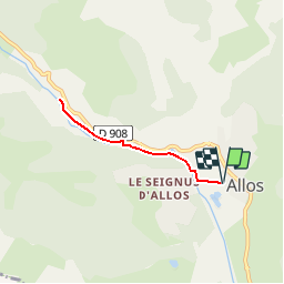
Trail Mountain bike of 5 km to be discovered at Provence-Alpes-Côte d'Azur, Alpes-de-Haute-Provence, Allos. This trail is proposed by tracegps.

Description

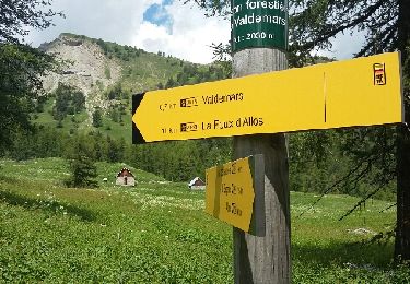
Espace VTT FFC Val d’Allos . Espace VTT FFC Val d'Allos - Circuit n° 06 - Prémin court Départ de Val d’Allos 1400 – Allos – Base de loisirs (passerelle) Circuit officiel labellisé par la Fédération Française de Cyclisme. L’espace VTT FFC du Val d’Allos – Haut Verdon vous propose plus de 100 kilomètres de pistes et chemins forestiers. Sous le soleil des Alpes de Haute Provence vous profiterez de la montagne sur des circuits adaptés pour tous les niveaux et toutes les envies. Parcours à profil descendant sur le site de Val d’Allos 1500 – Le Seignus, ou parcours vallonnés dans le reste de la vallée vous roulerez dans les sous-bois ou les alpages du pays des sources, des lacs et des montagnes.

Elevation profile

Photos

Positioning

Country:
France
Region :
Provence-Alpes-Côte d'Azur
Department/Province :
Alpes-de-Haute-Provence
Municipality :
Allos
Location:
Unknown
Start:(UTM)
310396 ; 4901396 (32T) N.

Trails nearby

Trail Walking Colmars - Col de l
Walking
Marchopier

Walking

Very difficult
Colmars, Provence-Alpes-Côte d'Azur, Alpes-de-Haute-Provence, France
17.1 km | 31 km-effort
7h 8min
Yes
Trail Walking Allos - Allos:rando à partir de la Haute Colette - Photo
Walking
halgrain

Walking

Medium
Allos, Provence-Alpes-Côte d'Azur, Alpes-de-Haute-Provence, France
4 km | 7.7 km-effort
3h 48min
Yes
Trail Walking Colmars - col de l'encombrette pas de L'Echellette - Photo
Walking
Joel26400

Walking

Very difficult
Colmars, Provence-Alpes-Côte d'Azur, Alpes-de-Haute-Provence, France
17.5 km | 32 km-effort
6h 11min
Yes
Trail Walking Allos - lac d allos - Photo
Walking
Mariephil

Walking

Very easy
Allos, Provence-Alpes-Côte d'Azur, Alpes-de-Haute-Provence, France
12.3 km | 19.8 km-effort
4h 49min
Yes
Trail 4x4 Allos - Piste de Bouchier - Photo
4x4
pascal06300

4x4

Very easy
Allos, Provence-Alpes-Côte d'Azur, Alpes-de-Haute-Provence, France
3.6 km | 5.8 km-effort
Unknown
No
Trail 4x4 Villars-Colmars - Piste de chasse  - Photo
4x4
pascal06300

4x4

Very easy
Villars-Colmars, Provence-Alpes-Côte d'Azur, Alpes-de-Haute-Provence, France
5.9 km | 7.2 km-effort
32min
No
Trail Walking Allos - MF de Valdemars - Photo
Walking
LtZIP

Walking

Medium
Allos, Provence-Alpes-Côte d'Azur, Alpes-de-Haute-Provence, France
14 km | 21 km-effort
4h 24min
Yes
Trail Walking Allos - Allos -Le Brec - Allos - Photo
Walking
jacobn

Walking

Very easy
Allos, Provence-Alpes-Côte d'Azur, Alpes-de-Haute-Provence, France
4.7 km | 6.6 km-effort
1h 25min
No
Trail Walking Allos - Rochecline - Photo
Walking
c100106

Walking

Difficult
Allos, Provence-Alpes-Côte d'Azur, Alpes-de-Haute-Provence, France
12.2 km | 26 km-effort
3h 21min
Yes


Close
My subscriptions