Trail Walking Saint-Genès-Champanelle - Autour de Chatrat - Photo
 tracegps
tracegps

User

© OpenStreetMap contributors
Length
Length
12.2 km
Max alt
Max alt
1018 m
Uphill gradient
Uphill gradient
277 m
Km-Effort
Km-Effort  
15.9 km
Min alt
Min alt
866 m
Downhill gradient
Downhill gradient
275 m
Boucle
Boucle
Yes
Creation date :
2014-12-10 00:00:00.0
Updated on :
2014-12-10 00:00:00.0

(0 Reviews)

Walking
Walking
2h19
Difficulty : Medium

Scan this QR Code to open this trail in the SityTrail application

FREE GPS app for hiking

Logo SityTrail SityTrail

IGN / Geographical institutes

Download SityTrail from the App Store Download SityTrail from Google Play

Logo SityTrail SityTrail World

The world is yours!

Download SityTrail from the App Store Download SityTrail from Google Play Download SityTrail on Huawei AppGallery

About

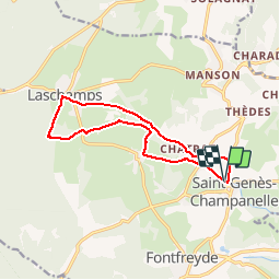
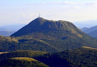
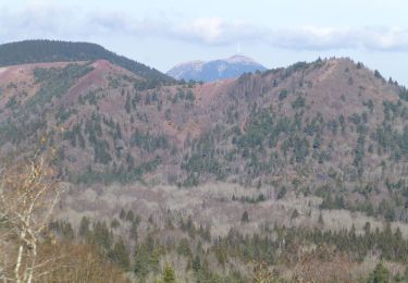
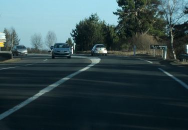
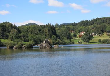
Trail Walking of 12.2 km to be discovered at Auvergne-Rhône-Alpes, Puy-de-Dôme, Saint-Genès-Champanelle. This trail is proposed by tracegps.

Description

Inspiré du circuit Chamina dans la chaîne des Puys, rallongé de 2,5 km. Terrain idéal quand on ne veut pas aller loin, pour se promener seul ou en famille, à pied ou en VTT ; j'ai même rencontré un cavalier! Balade numérisée sur le terrain par Jean louis Phillipart. Retrouvez cette randonnée dans le topo Guide Chamina Autour de Clermont.

Elevation profile

Positioning

Country:
France
Region :
Auvergne-Rhône-Alpes
Department/Province :
Puy-de-Dôme
Municipality :
Saint-Genès-Champanelle
Location:
Unknown
Start:(UTM)
501325 ; 5063120 (31T) N.

Trails nearby

Trail Walking Ceyrat - Ceyrat_Tour_Montrognon - Photo
Walking
GUIDE
jagarnier

Walking

Easy
(1)
Ceyrat, Auvergne-Rhône-Alpes, Puy-de-Dôme, France
7.2 km | 9.3 km-effort
2h 15min
Yes
Trail Walking Royat - Royat_Chemin_Ecoliers - Photo
Walking
GUIDE
jagarnier

Walking

Medium
(3)
Royat, Auvergne-Rhône-Alpes, Puy-de-Dôme, France
6.9 km | 11.2 km-effort
2h 17min
Yes
Trail Walking Royat - Oclede-GraveNoire-Charade_T - Photo
Walking
force

Walking

Medium
(1)
Royat, Auvergne-Rhône-Alpes, Puy-de-Dôme, France
10.3 km | 15.9 km-effort
1h 36min
Yes
Trail Walking Orcines - Ceyssat_Puy_Dome - Photo
Walking
GUIDE
jagarnier

Walking

Medium
(2)
Orcines, Auvergne-Rhône-Alpes, Puy-de-Dôme, France
7.3 km | 12.3 km-effort
2h 31min
Yes
Trail Walking Aydat - puy de Vichatel - Photo
Walking
bernardeau

Walking

Very easy
(1)
Aydat, Auvergne-Rhône-Alpes, Puy-de-Dôme, France
3.8 km | 5.8 km-effort
1h 13min
Yes
Trail Walking Orcines - Le tour du Puy de Dôme - Photo
Walking
tracegps

Walking

Difficult
(1)
Orcines, Auvergne-Rhône-Alpes, Puy-de-Dôme, France
12.2 km | 17.3 km-effort
3h 0min
Yes
Trail On foot Aydat - Les Cheires Hautes - Photo
On foot
PRO

On foot

Easy
Aydat, Auvergne-Rhône-Alpes, Puy-de-Dôme, France
15.9 km | 20 km-effort
4h 32min
Yes
Trail On foot Aydat - Le Lac de la Cassière - Photo
On foot
PRO

On foot

Easy
Aydat, Auvergne-Rhône-Alpes, Puy-de-Dôme, France
3.2 km | 4 km-effort
54min
Yes
Trail On foot Saint-Genès-Champanelle - Nadaillat - Photo
On foot
PRO

On foot

Easy
Saint-Genès-Champanelle, Auvergne-Rhône-Alpes, Puy-de-Dôme, France
6.6 km | 9.3 km-effort
2h 7min
Yes


Close
My subscriptions