Trail Walking Bayonne - Bayonne Hendaye - Photo
 tracegps
tracegps

User

© OpenStreetMap contributors
Length
Length
48 km
Max alt
Max alt
78 m
Uphill gradient
Uphill gradient
828 m
Km-Effort
Km-Effort  
59 km
Min alt
Min alt
-3 m
Downhill gradient
Downhill gradient
830 m
Boucle
Boucle
No
Creation date :
2014-12-10 00:00:00.0
Updated on :
2014-12-10 00:00:00.0

(0 Reviews)

Walking
Walking
12h00
Difficulty : Difficult

Scan this QR Code to open this trail in the SityTrail application

FREE GPS app for hiking

Logo SityTrail SityTrail

IGN / Geographical institutes

Download SityTrail from the App Store Download SityTrail from Google Play

Logo SityTrail SityTrail World

The world is yours!

Download SityTrail from the App Store Download SityTrail from Google Play Download SityTrail on Huawei AppGallery

About

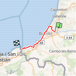
Trail Walking of 48 km to be discovered at New Aquitaine, Pyrénées-Atlantiques, Bayonne. This trail is proposed by tracegps.

Description

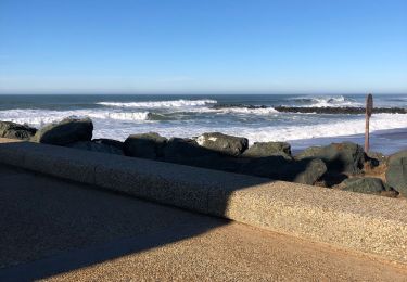
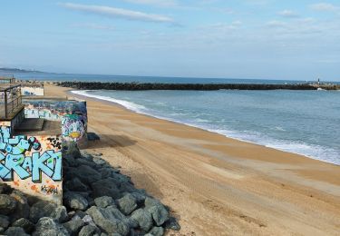
Circuit reliant Bayonne à Hendaye en suivant au plus près la Cote Basque. Évidement la sente du douanier n'a pu être partout reconstitué en particulier du coté de St Jean de luz et du golf de Bidart puisque le passage par le bord de l'océan est déconseillé (éboulement). Depuis la plage d'Erretegia à Bidart jusqu'au domaine d'Abbadia à Hendaye, le conseil général du 64 a aménagé un sentier côtier qui longe en grande partie la route de la corniche (créée en 1947). Nous terminerons par la plage d'Hendaye pour rejoindre ensuite l'embarcadère de Sokoburu puisque ce chemin à une suite. Depuis Hondarribia il rejoint Donostia (san sebastien) en passant au plus prés du rivage par un circuit lui aussi très difficile comportant quelques pas d'escalade.

Elevation profile

Points of interest

Point of interest Hendaye - pointe_ste_anne - Photo
tracegps
Point of interest Hendaye - maison_de_la_lande - Photo
tracegps
Point of interest Bidart - erretegia - Photo
tracegps
BIDART 
Point of interest Saint-Jean-de-Luz - chapelle_chevalier_van_bree - Photo
tracegps
SAINT-JEAN-DE-LUZ 
Point of interest Anglet - bois_du_lazaret - Photo
tracegps
Point of interest Anglet - brise_lame - Photo
tracegps
ANGLET 
Point of interest Biarritz - phare_de_Biarritz - Photo
tracegps
Point of interest Biarritz - port_de_Biarritz - Photo
tracegps
Point of interest Biarritz - Port_Vieux_playa - Photo
tracegps
Point of interest Biarritz - Villa_Belza - Photo
tracegps
BIARRITZ 
Point of interest Biarritz - maison_de_Henry_Russell - Photo
tracegps
Point of interest Biarritz - cote_des_basques - Photo
tracegps
Point of interest Anglet - promenade_Lazaret - Photo
tracegps
Point of interest Anglet - ruiseau - Photo
tracegps
ANGLET 
Point of interest Guéthary - Port_de_guethary_Getaria - Photo
tracegps
Point of interest Guéthary - Senix - Photo
tracegps
GUÉTHARY 
Point of interest Saint-Jean-de-Luz - maiarko - Photo
tracegps
SAINT-JEAN-DE-LUZ 
Point of interest Saint-Jean-de-Luz - erromardi - Photo
tracegps
SAINT-JEAN-DE-LUZ 
Point of interest Saint-Jean-de-Luz - Ign_Arxilua - Photo
tracegps
SAINT-JEAN-DE-LUZ 
Point of interest Saint-Jean-de-Luz - Balise_puerto_san_juan_de_luz - Photo
tracegps
Point of interest Saint-Jean-de-Luz - Balise_puerto_san_juan_de_luz - Photo
tracegps

Positioning

Country:
France
Region :
New Aquitaine
Department/Province :
Pyrénées-Atlantiques
Municipality :
Bayonne
Location:
Unknown
Start:(UTM)
623842 ; 4816383 (30T) N.

Trails nearby

Trail Walking Anglet - Forêts de Pignada et Chiberta - Anglet - Photo
Walking
tracegps

Walking

Medium
(2)
Anglet, New Aquitaine, Pyrénées-Atlantiques, France
8.1 km | 9.6 km-effort
2h 0min
Yes
Trail Walking Mouguerre - La croix de Mouguerre  - Photo
Walking
tracegps

Walking

Easy
(2)
Mouguerre, New Aquitaine, Pyrénées-Atlantiques, France
6.5 km | 8.8 km-effort
1h 45min
Yes
Trail Walking Bayonne - Plaine d'ANSOT Bayonne - Photo
Walking
jaja64

Walking

Easy
Bayonne, New Aquitaine, Pyrénées-Atlantiques, France
8.4 km | 9 km-effort
2h 13min
Yes
Trail Walking Anglet - Promenade Victor Mendiboure Anglet - Photo
Walking
jaja64

Walking

Easy
Anglet, New Aquitaine, Pyrénées-Atlantiques, France
9.1 km | 9.7 km-effort
1h 43min
Yes
Trail Walking Saint-Pierre-d'Irube - balade decouverte Mouguerre - Photo
Walking
alex12r

Walking

Difficult
Saint-Pierre-d'Irube, New Aquitaine, Pyrénées-Atlantiques, France
5.7 km | 7.6 km-effort
1h 56min
Yes
Trail Walking Bayonne - jour 12, le 06/07/2023 - Photo
Walking
Céline Charbonnieras

Walking

Difficult
Bayonne, New Aquitaine, Pyrénées-Atlantiques, France
14.8 km | 16.8 km-effort
3h 26min
No
Trail Walking Bayonne - Manif 1er Mai 2023 Bayonne  - Photo
Walking
Maikel bazar

Walking

Medium
Bayonne, New Aquitaine, Pyrénées-Atlantiques, France
6 km | 6.9 km-effort
2h 3min
Yes
Trail Walking Bayonne - Eté 2023 / Jour 12 - Photo
Walking
Céline Charbonnieras

Walking

Difficult
Bayonne, New Aquitaine, Pyrénées-Atlantiques, France
14.4 km | 16 km-effort
3h 38min
No
Trail Mountain bike Anglet - Anglet Biarritz Anglet Bayonne - Photo
Mountain bike
Pat_83200

Mountain bike

Very easy
Anglet, New Aquitaine, Pyrénées-Atlantiques, France
24 km | 26 km-effort
2h 31min
Yes


Close
My subscriptions