Trail Mountain bike Aspres-sur-Buëch - Blaireau 2008 - Aspres sur Buech - Photo
 tracegps
tracegps

User

© OpenStreetMap contributors
Length
Length
36 km
Max alt
Max alt
1325 m
Uphill gradient
Uphill gradient
1211 m
Km-Effort
Km-Effort  
52 km
Min alt
Min alt
719 m
Downhill gradient
Downhill gradient
1211 m
Boucle
Boucle
Yes
Creation date :
2014-12-10 00:00:00.0
Updated on :
2014-12-10 00:00:00.0

(0 Reviews)

Mountain bike
Mountain bike
4h00
Difficulty : Very difficult

Scan this QR Code to open this trail in the SityTrail application

FREE GPS app for hiking

Logo SityTrail SityTrail

IGN / Geographical institutes

Download SityTrail from the App Store Download SityTrail from Google Play

Logo SityTrail SityTrail World

The world is yours!

Download SityTrail from the App Store Download SityTrail from Google Play Download SityTrail on Huawei AppGallery

About

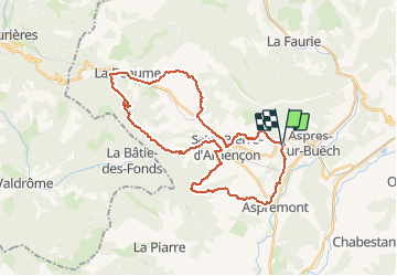
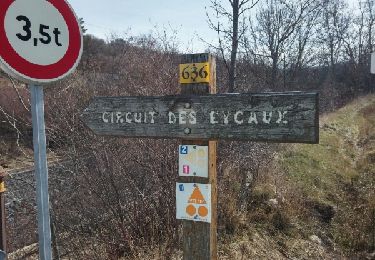
Trail Mountain bike of 36 km to be discovered at Provence-Alpes-Côte d'Azur, Hautes-Alpes, Aspres-sur-Buëch. This trail is proposed by tracegps.

Description

Une très belle randonnée qui a été proposée par Rando Buech. Des montées infernales et de très belles descentes....Prévoir de bonnes jambes.

Elevation profile

Positioning

Country:
France
Region :
Provence-Alpes-Côte d'Azur
Department/Province :
Hautes-Alpes
Municipality :
Aspres-sur-Buëch
Location:
Unknown
Start:(UTM)
717167 ; 4933415 (31T) N.

Trails nearby

Trail Walking Aspres-sur-Buëch - R42   La Longeagne - Photo
Walking
GUIDE+

Walking

Very easy
(1)
Aspres-sur-Buëch, Provence-Alpes-Côte d'Azur, Hautes-Alpes, France
7.1 km | 11.2 km-effort
2h 23min
Yes
Trail Running Aspres-sur-Buëch - Trail 06 - La Longeagne - Photo
Running
GUIDE+

Running

Difficult
Aspres-sur-Buëch, Provence-Alpes-Côte d'Azur, Hautes-Alpes, France
9.7 km | 19.1 km-effort
2h 0min
Yes
Trail Walking Aspres-sur-Buëch - Aspres sur Buech Antennes - Photo
Walking
Marco05

Walking

Medium
Aspres-sur-Buëch, Provence-Alpes-Côte d'Azur, Hautes-Alpes, France
9.9 km | 19.4 km-effort
4h 24min
Yes
Trail Mountain bike Aspres-sur-Buëch - Gorges de l'Agnielle - Photo
Mountain bike
jeanboulay

Mountain bike

Medium
Aspres-sur-Buëch, Provence-Alpes-Côte d'Azur, Hautes-Alpes, France
12 km | 16.7 km-effort
2h 25min
Yes
Trail Walking Chabestan - Champignons Chabestan - Photo
Walking
GUIDE
harydh

Walking

Easy
Chabestan, Provence-Alpes-Côte d'Azur, Hautes-Alpes, France
3.5 km | 4.6 km-effort
1h 39min
Yes
Trail Walking Aspres-sur-Buëch - Circuit des Eygau.(09-03-17) - Photo
Walking
Dervalmarc

Walking

Easy
Aspres-sur-Buëch, Provence-Alpes-Côte d'Azur, Hautes-Alpes, France
13.2 km | 17.4 km-effort
2h 17min
Yes
Trail Walking Aspres-sur-Buëch - Circuit de la Digue. - Photo
Walking
Dervalmarc

Walking

Easy
Aspres-sur-Buëch, Provence-Alpes-Côte d'Azur, Hautes-Alpes, France
6.1 km | 8.1 km-effort
1h 2min
Yes
Trail Mountain bike Saint-Pierre-d'Argençon - HA J3 long - Photo
Mountain bike
thierryd

Mountain bike

Very easy
(4)
Saint-Pierre-d'Argençon, Provence-Alpes-Côte d'Azur, Hautes-Alpes, France
34 km | 42 km-effort
2h 45min
No
Trail Walking La Beaume - Ranc de Chamoussière - Crête de la Longeagne - Photo
Walking
PapouBertrand

Walking

Very difficult
La Beaume, Provence-Alpes-Côte d'Azur, Hautes-Alpes, France
12.9 km | 23 km-effort
5h 17min
Yes


Close
My subscriptions