Trail Mountain bike Chazemais - Rando VTT Chazemais - Photo
 tracegps
tracegps

User

© OpenStreetMap contributors
Length
Length
29 km
Max alt
Max alt
319 m
Uphill gradient
Uphill gradient
362 m
Km-Effort
Km-Effort  
34 km
Min alt
Min alt
210 m
Downhill gradient
Downhill gradient
360 m
Boucle
Boucle
Yes
Creation date :
2014-12-10 00:00:00.0
Updated on :
2014-12-10 00:00:00.0

(2 Reviews)

Mountain bike
Mountain bike
2h19
Difficulty : Medium

Scan this QR Code to open this trail in the SityTrail application

FREE GPS app for hiking

Logo SityTrail SityTrail

IGN / Geographical institutes

Download SityTrail from the App Store Download SityTrail from Google Play

Logo SityTrail SityTrail World

The world is yours!

Download SityTrail from the App Store Download SityTrail from Google Play Download SityTrail on Huawei AppGallery

About

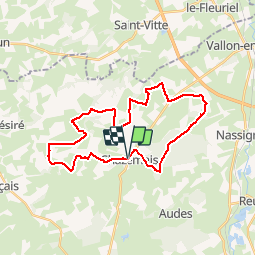
Trail Mountain bike of 29 km to be discovered at Auvergne-Rhône-Alpes, Allier, Chazemais. This trail is proposed by tracegps.

Description

Départ du parking de l'église. Direction route de Vallon en Sully, puis à droite (chemin pédestre fléché en jaune) direction La Lande puis à gauche pour le Bois du Dela jusqu'à Champrallier. A gauche par Villèvendre et, traversée de la départementale de Vallon, Les Boutais, à gauche pour Puy Bouilland. Traversée de Bois Menu. Retour sur Chazemais par Moulin Galet et La Prugne. Circuit boueux en cas de condition humide.

Elevation profile

Positioning

Country:
France
Region :
Auvergne-Rhône-Alpes
Department/Province :
Allier
Municipality :
Chazemais
Location:
Unknown
Start:(UTM)
463591 ; 5147867 (31T) N.

Comments

Please log in to post a review or rate the element


Très belle région, belle préparation, je vais le faire bientôt et le proposer Aux Baboteurs de Vallon...


Trails nearby

Trail Walking Chazemais - Circuit du Centre de la France  - Chazemais - Photo
Walking
tracegps

Walking

Very difficult
Chazemais, Auvergne-Rhône-Alpes, Allier, France
16.7 km | 19 km-effort
4h 10min
Yes
Trail Mountain bike Audes - Audes - Magnette - Photo
Mountain bike
Arnoldr8491

Mountain bike

Medium
Audes, Auvergne-Rhône-Alpes, Allier, France
15 km | 17.5 km-effort
1h 9min
Yes
Trail Other activity Audes - balade - Photo
Other activity
cello.eos400d

Other activity

Very easy
Audes, Auvergne-Rhône-Alpes, Allier, France
7.1 km | 8.2 km-effort
1h 44min
No
Trail Mountain bike Saint-Vitte - Saint Vitte - Champvalier - Nassigny - Vallon - Photo
Mountain bike
Arnoldr8491

Mountain bike

Medium
Saint-Vitte, Centre-Loire Valley, Cher, France
15.6 km | 17.3 km-effort
1h 28min
No


Close
My subscriptions