Trail Walking Murol - La Roche Romaine - Photo
 tracegps
tracegps

User

© OpenStreetMap contributors
Length
Length
10.8 km
Max alt
Max alt
1033 m
Uphill gradient
Uphill gradient
295 m
Km-Effort
Km-Effort  
14.8 km
Min alt
Min alt
808 m
Downhill gradient
Downhill gradient
296 m
Boucle
Boucle
Yes
Creation date :
2014-12-10 00:00:00.0
Updated on :
2014-12-10 00:00:00.0

(0 Reviews)

Walking
Walking
2h40
Difficulty : Medium

Scan this QR Code to open this trail in the SityTrail application

FREE GPS app for hiking

Logo SityTrail SityTrail

IGN / Geographical institutes

Download SityTrail from the App Store Download SityTrail from Google Play

Logo SityTrail SityTrail World

The world is yours!

Download SityTrail from the App Store Download SityTrail from Google Play Download SityTrail on Huawei AppGallery

About

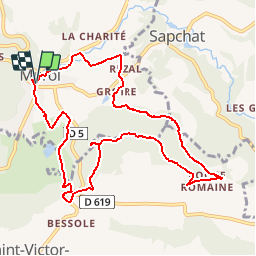
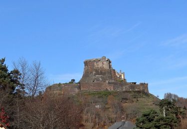
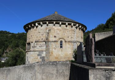
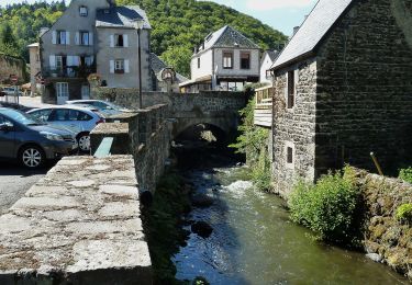
Trail Walking of 10.8 km to be discovered at Auvergne-Rhône-Alpes, Puy-de-Dôme, Murol. This trail is proposed by tracegps.

Description

L'itinéraire, comme celui du Lac Chambon est très agréable et fait découvrir, sous tous les angles, le château médiéval de MUROL. La forteresse érigée au XIIe siècle a maintes fois remaniée au cours des siècles. Laissée à l'abandon jusque dans les années 1870, elle fait aujourd'hui l'objet de toutes les attentions. A visiter!

Elevation profile

Photos

Points of interest

Point of interest Murol - départ - Photo
tracegps
MUROL 
Point of interest Saint-Victor-la-Rivière - La Roche Romaine - Photo
tracegps
SAINT-VICTOR-LA-RIVIÈRE 
Point of interest Saint-Victor-la-Rivière - Panorama - Photo
tracegps
SAINT-VICTOR-LA-RIVIÈRE 

Positioning

Country:
France
Region :
Auvergne-Rhône-Alpes
Department/Province :
Puy-de-Dôme
Municipality :
Murol
Location:
Unknown
Start:(UTM)
495485 ; 5046576 (31T) N.

Trails nearby

Trail Walking Chambon-sur-Lac - Chambon_Couze_Surains - Photo
Walking
GUIDE
jagarnier

Walking

Medium
(1)
Chambon-sur-Lac, Auvergne-Rhône-Alpes, Puy-de-Dôme, France
11.3 km | 16.7 km-effort
3h 30min
Yes
Trail Walking Le Vernet-Sainte-Marguerite - Vernet_Puy_Alou - Photo
Walking
GUIDE
jagarnier

Walking

Medium
(1)
Le Vernet-Sainte-Marguerite, Auvergne-Rhône-Alpes, Puy-de-Dôme, France
9.9 km | 13.1 km-effort
2h 50min
Yes
Trail Walking Saint-Victor-la-Rivière - St_Victor_Foret_Courbanges - Photo
Walking
GUIDE
jagarnier

Walking

Medium
(1)
Saint-Victor-la-Rivière, Auvergne-Rhône-Alpes, Puy-de-Dôme, France
10.3 km | 14.8 km-effort
3h 0min
Yes
Trail Walking Murol - Lac Chambon et château médiéval de Murol - Photo
Walking
tracegps

Walking

Medium
(4)
Murol, Auvergne-Rhône-Alpes, Puy-de-Dôme, France
8.9 km | 13.4 km-effort
2h 15min
Yes
Trail Walking Murol - Murol_Marais_Chambon - Photo
Walking
GUIDE
jagarnier

Walking

Medium
(1)
Murol, Auvergne-Rhône-Alpes, Puy-de-Dôme, France
7 km | 10.9 km-effort
2h 0min
Yes
Trail On foot Chambon-sur-Lac - Voissière - Photo
On foot
PRO

On foot

Easy
Chambon-sur-Lac, Auvergne-Rhône-Alpes, Puy-de-Dôme, France
9.4 km | 15 km-effort
3h 24min
Yes
Trail On foot Saint-Victor-la-Rivière - Roche-Romaine - Photo
On foot
PRO

On foot

Easy
Saint-Victor-la-Rivière, Auvergne-Rhône-Alpes, Puy-de-Dôme, France
10.1 km | 13.8 km-effort
3h 7min
Yes
Trail On foot Le Vernet-Sainte-Marguerite - Le Puy d'Alou - Photo
On foot
PRO

On foot

Easy
Le Vernet-Sainte-Marguerite, Auvergne-Rhône-Alpes, Puy-de-Dôme, France
9.3 km | 12 km-effort
2h 43min
Yes
Trail On foot Saint-Nectaire - Les Grottes de Châteauneuf - Photo
On foot
PRO

On foot

Easy
Saint-Nectaire, Auvergne-Rhône-Alpes, Puy-de-Dôme, France
4.9 km | 7.7 km-effort
1h 45min
No


Close
My subscriptions