Trail Walking Salvezines - La forêt d  en Malo depuis le Caunil (11) - Photo

La forêt d en Malo depuis le Caunil (11)

© OpenStreetMap contributors
Length
Length
13.2 km
Max alt
Max alt
1460 m
Uphill gradient
Uphill gradient
689 m
Km-Effort
Km-Effort  
22 km
Min alt
Min alt
852 m
Downhill gradient
Downhill gradient
698 m
Boucle
Boucle
Yes
Creation date :
2019-05-27 16:39:46.548
Updated on :
2019-05-27 16:39:46.781

(1 Reviews)

Walking
Walking
5h22
Difficulty : Medium

Scan this QR Code to open this trail in the SityTrail application

FREE GPS app for hiking

Logo SityTrail SityTrail

IGN / Geographical institutes

Download SityTrail from the App Store Download SityTrail from Google Play

Logo SityTrail SityTrail World

The world is yours!

Download SityTrail from the App Store Download SityTrail from Google Play Download SityTrail on Huawei AppGallery

About

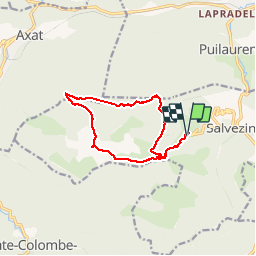
Trail Walking of 13.2 km to be discovered at Occitania, Aude, Salvezines. This trail is proposed by MarieFrancoise.

Description

Départ après le Caunil.dans un virage garer les voitures .le sentier part sur la gauche au niveau des boïtes à lettres
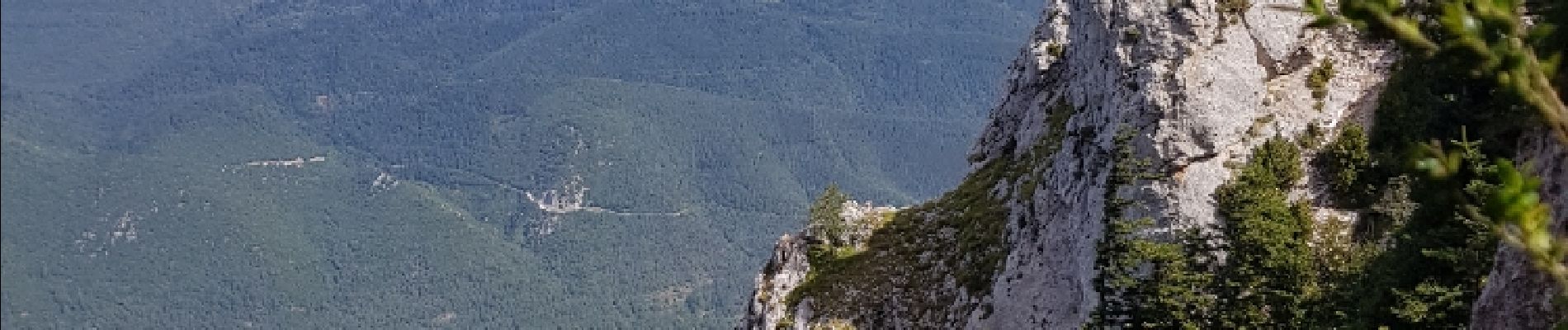
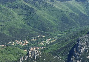
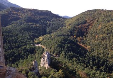
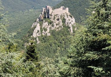
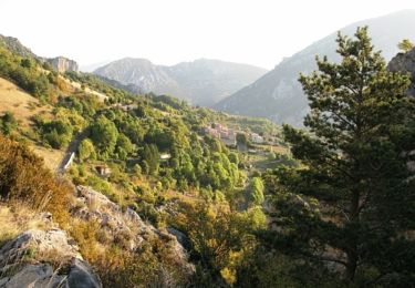
jolie rando en forêt et sur les crêtes .jolis panoramas

Elevation profile

Photos

Points of interest

Point of interest Salvezines - Point 1 - Photo
MarieFrancoise
SALVEZINES 

Positioning

Country:
France
Region :
Occitania
Department/Province :
Aude
Municipality :
Salvezines
Location:
Unknown
Start:(UTM)
441888 ; 4736484 (31T) N.

Comments

Please log in to post a review or rate the element


faite dans le sens inverse. superbe randonnée !


Trails nearby

Trail Walking Salvezines - Forêt d’enmalo - Photo
Walking
ezola

Walking

Difficult
Salvezines, Occitania, Aude, France
10.1 km | 16.9 km-effort
3h 24min
Yes
Trail Walking Salvezines - Le Caunil. Maison forestière par Puylaurens  - Photo
Walking
robertperello

Walking

Difficult
Salvezines, Occitania, Aude, France
10 km | 16.2 km-effort
2h 45min
Yes
Trail Walking  - Puilaurens Chateau - Photo
Walking
livfoss

Walking

Easy
, Occitania, Aude, France
3.3 km | 6.2 km-effort
1h 12min
Yes
Trail Walking Axat - axat château de puylaurens - Photo
Walking
marcagif

Walking

Easy
Axat, Occitania, Aude, France
22 km | 33 km-effort
6h 27min
Yes
Trail Walking Salvezines - Autour du Pic d'Estable - Salvezine - Photo
Walking
tracegps

Walking

Difficult
Salvezines, Occitania, Aude, France
16.1 km | 27 km-effort
5h 30min
Yes
Trail Walking Puilaurens - château de Puilaurens  - Photo
Walking
batut

Walking

Very easy
Puilaurens, Occitania, Aude, France
13.7 km | 21 km-effort
4h 40min
Yes
Trail Running Saint-Martin-Lys - enchaînement vélo / course à pied au d'Axat - Photo
Running
JohandePertuis

Running

Difficult
Saint-Martin-Lys, Occitania, Aude, France
59 km | 89 km-effort
55min
Yes
Trail Walking Puilaurens - 11_Aigues Bonnes_Quirbajou_J4 - Photo
Walking
jab31

Walking

Difficult
Puilaurens, Occitania, Aude, France
26 km | 39 km-effort
9h 51min
No
Trail Walking Puilaurens - Cathares E6 Puilaurens - Prugnanes 07.06.2019 - Photo
Walking
GUIDE
Kargil

Walking

Difficult
Puilaurens, Occitania, Aude, France
25 km | 36 km-effort
7h 30min
No


Close
My subscriptions