Trail Walking Saint-Cyr-sur-Mer - Le Port d'Alon - Photo
 tracegps
tracegps

User

© OpenStreetMap contributors
Length
Length
9.4 km
Max alt
Max alt
100 m
Uphill gradient
Uphill gradient
255 m
Km-Effort
Km-Effort  
12.8 km
Min alt
Min alt
4 m
Downhill gradient
Downhill gradient
255 m
Boucle
Boucle
Yes
Creation date :
2014-12-10 00:00:00.0
Updated on :
2014-12-10 00:00:00.0

(2 Reviews)

Walking
Walking
3h00
Difficulty : Medium

Scan this QR Code to open this trail in the SityTrail application

FREE GPS app for hiking

Logo SityTrail SityTrail

IGN / Geographical institutes

Download SityTrail from the App Store Download SityTrail from Google Play

Logo SityTrail SityTrail World

The world is yours!

Download SityTrail from the App Store Download SityTrail from Google Play Download SityTrail on Huawei AppGallery

About

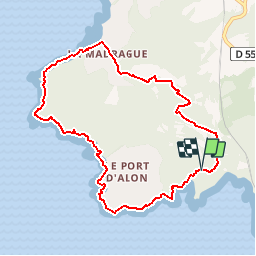
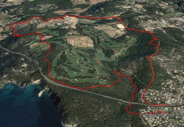
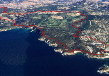
Trail Walking of 9.4 km to be discovered at Provence-Alpes-Côte d'Azur, Var, Saint-Cyr-sur-Mer. This trail is proposed by tracegps.

Description

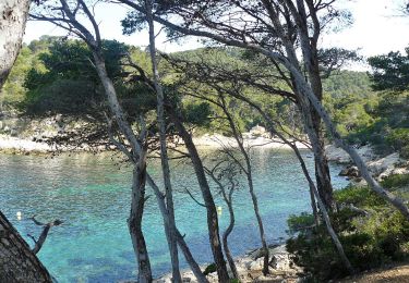
Très belle randonnée avec vue sur mer. Sentier accessible à pied uniquement le long de la cote.La partie à l'intérieur des terres suit un chemin balisé avec des panneaux informatifs sur l'endroit. Difficulté niveau 4. Retrouvez d’autres informations sur le site de Rando Loisirs à Carnoux en Provence.

Elevation profile

Photos

Positioning

Country:
France
Region :
Provence-Alpes-Côte d'Azur
Department/Province :
Var
Municipality :
Saint-Cyr-sur-Mer
Location:
Unknown
Start:(UTM)
720510 ; 4780932 (31T) N.

Comments

Please log in to post a review or rate the element


Très belle balade.


Trails nearby

Trail Walking Bandol - SityTrail - fregate - Photo
Walking
GUIDE
affinetataille

Walking

Easy
(1)
Bandol, Provence-Alpes-Côte d'Azur, Var, France
8.7 km | 11.4 km-effort
3h 15min
Yes
Trail Walking Bandol - SityTrail - Tour du golf de la Fregate (version longue ) - Photo
Walking
GUIDE
affinetataille

Walking

Very difficult
(1)
Bandol, Provence-Alpes-Côte d'Azur, Var, France
13.5 km | 19 km-effort
4h 19min
Yes
Trail Walking Saint-Cyr-sur-Mer - St Cyr  - Bandol - Photo
Walking
kephas

Walking

Medium
(1)
Saint-Cyr-sur-Mer, Provence-Alpes-Côte d'Azur, Var, France
16.1 km | 21 km-effort
4h 53min
No
Trail Walking Saint-Cyr-sur-Mer - Port d'Alon - Bandol - Port d'Alon - Photo
Walking
tracegps

Walking

Medium
(1)
Saint-Cyr-sur-Mer, Provence-Alpes-Côte d'Azur, Var, France
7.7 km | 9.9 km-effort
2h 0min
Yes
Trail Walking Bandol - Rando Bandol - Port d'Alon - Bandol - Photo
Walking
tracegps

Walking

Difficult
(1)
Bandol, Provence-Alpes-Côte d'Azur, Var, France
7.2 km | 9.4 km-effort
2h 30min
Yes
Trail On foot Saint-Cyr-sur-Mer - Sentier du littoral (Saint-Cyr-sur-Mer) - Photo
On foot
PRO

On foot

Easy
Saint-Cyr-sur-Mer, Provence-Alpes-Côte d'Azur, Var, France
4.9 km | 6.5 km-effort
1h 27min
No
Trail Walking Bandol - SityTrail - Boucle Bandol - Port d'Alon - Dune de sable - La Madrague - Port d'Alon - Bandol - Photo
Walking
GUIDE
affinetataille

Walking

Medium
(2)
Bandol, Provence-Alpes-Côte d'Azur, Var, France
14.1 km | 19.7 km-effort
6h 0min
Yes
Trail Walking Bandol - bandol baie des nations - Photo
Walking
bopapa

Walking

Very easy
(1)
Bandol, Provence-Alpes-Côte d'Azur, Var, France
13.2 km | 16.8 km-effort
5h 44min
Yes
Trail Walking Saint-Cyr-sur-Mer - le sentier littoral de la Madrague et la colline de sable - Photo
Walking
GUIDE
amiral13

Walking

Easy
(1)
Saint-Cyr-sur-Mer, Provence-Alpes-Côte d'Azur, Var, France
13 km | 18.7 km-effort
5h 20min
Yes


Close
My subscriptions