Trail Mountain bike Cierrey - Randonnée de Cierrey 2009 - Photo

Randonnée de Cierrey 2009

 tracegps
tracegps

User

© OpenStreetMap contributors
Length
Length
66 km
Max alt
Max alt
142 m
Uphill gradient
Uphill gradient
1052 m
Km-Effort
Km-Effort  
80 km
Min alt
Min alt
31 m
Downhill gradient
Downhill gradient
1052 m
Boucle
Boucle
Yes
Creation date :
2014-12-10 00:00:00.0
Updated on :
2014-12-10 00:00:00.0

(2 Reviews)

Mountain bike
Mountain bike
3h30
Difficulty : Very difficult

Scan this QR Code to open this trail in the SityTrail application

FREE GPS app for hiking

Logo SityTrail SityTrail

IGN / Geographical institutes

Download SityTrail from the App Store Download SityTrail from Google Play

Logo SityTrail SityTrail World

The world is yours!

Download SityTrail from the App Store Download SityTrail from Google Play Download SityTrail on Huawei AppGallery

About

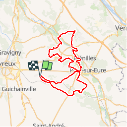
Trail Mountain bike of 66 km to be discovered at Normandy, Eure, Cierrey. This trail is proposed by tracegps.

Description

Voici la "RANDONNÉE DE LA POMMERAIE" organisée par le Club de Cierrey. Le parcours est difficile par son tracé très vallonné. Départ sur le plateau, pour descendre dans la vallée, direction les collines qui donnent sur le plateau en direction de Vernon. Pour le retour, descente sur la vallée de l'Eure pour passer dans Fontaine sous Jouy, pour remonter sur le plateau en direction d'Évreux. Cette randonnée est programmée chaque année sur le même weekend du mois de septembre. Il vous propose 4 circuits Vtt (15-35-50-65km) ainsi que des parcours routiers. Voici les coordonnées du Club (cierrey27-cyclo.fr) Bonne randonnée à tous

Elevation profile

Positioning

Country:
France
Region :
Normandy
Department/Province :
Eure
Municipality :
Cierrey
Location:
Unknown
Start:(UTM)
371971 ; 5429262 (31U) N.

Comments

Please log in to post a review or rate the element


bienquelques cotesde belles vues - bienquelques cotesde belles vues


Trails nearby

Trail Equestrian La Trinité - BALADE 1 - Photo
Equestrian
iosine

Equestrian

Medium
(1)
La Trinité, Normandy, Eure, France
27 km | 31 km-effort
Unknown
Yes
Trail Equestrian La Trinité - RANDO CHEVAL - Photo
Equestrian
iosine

Equestrian

Very easy
(1)
La Trinité, Normandy, Eure, France
99 km | 110 km-effort
Unknown
No
Trail Walking Huest - les trois etangs - Photo
Walking
bernard.bonafous@free.fr

Walking

Very difficult
(1)
Huest, Normandy, Eure, France
25 km | 28 km-effort
6h 25min
Yes
Trail Walking Le Cormier - Le Cormier - Photo
Walking
vagalam49

Walking

Easy
(1)
Le Cormier, Normandy, Eure, France
8.8 km | 10.1 km-effort
2h 1min
Yes
Trail Walking Miserey - jean pierre chorte  - Photo
Walking
JamesVautier

Walking

Easy
Miserey, Normandy, Eure, France
9.3 km | 10.3 km-effort
2h 16min
Yes
Trail Walking Caillouet-Orgeville - 2023_05_Caillouet Sud Le Plessis - Photo
Walking
jeanlucien

Walking

Medium
Caillouet-Orgeville, Normandy, Eure, France
13.1 km | 15.3 km-effort
2h 45min
Yes
Trail Walking Miserey - les pommiers plus - Photo
Walking
JamesVautier

Walking

Easy
Miserey, Normandy, Eure, France
9.6 km | 11 km-effort
2h 17min
Yes
Trail Walking Huest - huest ,gravigni - Photo
Walking
JamesVautier

Walking

Easy
Huest, Normandy, Eure, France
9.6 km | 11.8 km-effort
3h 4min
Yes
Trail Cycle Évreux - Netreville Fauville Huest forêt du Boulay-Morin - Photo
Cycle
librefredy

Cycle

Easy
Évreux, Normandy, Eure, France
13 km | 15.2 km-effort
53min
Yes


Close
My subscriptions