Trail Mountain bike Saint-Lary-Soulan - Crête d'Azet - Saint Lary - Photo

Crête d'Azet - Saint Lary

 tracegps
tracegps

User

© OpenStreetMap contributors
Length
Length
40 km
Max alt
Max alt
1734 m
Uphill gradient
Uphill gradient
1422 m
Km-Effort
Km-Effort  
59 km
Min alt
Min alt
748 m
Downhill gradient
Downhill gradient
1423 m
Boucle
Boucle
Yes
Creation date :
2014-12-10 00:00:00.0
Updated on :
2014-12-10 00:00:00.0

(0 Reviews)

Mountain bike
Mountain bike
4h00
Difficulty : Difficult

Scan this QR Code to open this trail in the SityTrail application

FREE GPS app for hiking

Logo SityTrail SityTrail

IGN / Geographical institutes

Download SityTrail from the App Store Download SityTrail from Google Play

Logo SityTrail SityTrail World

The world is yours!

Download SityTrail from the App Store Download SityTrail from Google Play Download SityTrail on Huawei AppGallery

About

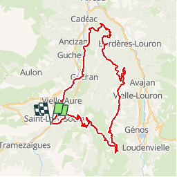
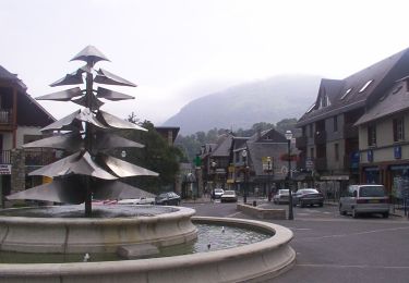
Trail Mountain bike of 40 km to be discovered at Occitania, Hautespyrenees, Saint-Lary-Soulan. This trail is proposed by tracegps.

Description

Nous commençons la boucle à la station de Saint Lary, et à l'extrémité supérieure du village, prendre la direction du village de Sailhan. A Sailhan, prendre Estensan, puis Azet (village). Méfiez-vous de ne pas prendre à ENS, une route secondaire en cul-de-sac. Au le village d’Azet le col du même nom, un célèbre point de départ pour parapente. Depuis le col commence la partie Offroads. Nous prenons une piste menant du Nord à un petit immeuble situé sur le haut de la colline (environ 150 mètres supplémentaires à gravir!) La suite est racontée ici.

Elevation profile

Photos

Points of interest

Point of interest Saint-Lary-Soulan - WP 1 - Photo
tracegps
SAINT-LARY-SOULAN 

Positioning

Country:
France
Region :
Occitania
Department/Province :
Hautespyrenees
Municipality :
Saint-Lary-Soulan
Location:
Unknown
Start:(UTM)
280675 ; 4743469 (31T) N.

Trails nearby

Trail Walking Saint-Lary-Soulan - 2011-08-03 15h51m06 - Photo
Walking
tchab

Walking

Very easy
(2)
Saint-Lary-Soulan, Occitania, Hautespyrenees, France
6.8 km | 9.8 km-effort
Unknown
Yes
Trail Walking Ens - lacs de Consaterre - Photo
Walking
GUIDE
lhomme.ph

Walking

Difficult
(1)
Ens, Occitania, Hautespyrenees, France
16.5 km | 34 km-effort
6h 56min
Yes
Trail Walking Azet - 2023-09-10 Azet-Col d'Azet crète de la Serre - Photo
Walking
Mich&Agnès

Walking

Very difficult
Azet, Occitania, Hautespyrenees, France
11.8 km | 19.4 km-effort
4h 24min
Yes
Trail sport Tramezaïgues - Au dessus de tramezaigues - Photo
sport
PVERTICAL

sport

Very easy
Tramezaïgues, Occitania, Hautespyrenees, France
3 km | 5.8 km-effort
Unknown
Yes
Trail On foot Saint-Lary-Soulan - Boucle de Caneilles - Photo
On foot
PRO

On foot

Easy
Saint-Lary-Soulan, Occitania, Hautespyrenees, France
4.2 km | 6.2 km-effort
1h 25min
No
Trail Walking Bourisp - GR 10 - 27ème étape : Vielle Aure - Bourisp - Azet - Col d’Azet - Loudenvielle Germ  - Photo
Walking
LEGUE

Walking

Medium
Bourisp, Occitania, Hautespyrenees, France
12.7 km | 26 km-effort
3h 29min
No
Trail Walking Bourisp - Camping Rioumajou - Agos - route de Soulan - Agos - Rioumajou à Bourisp - Photo
Walking
Forsans

Walking

Difficult
Bourisp, Occitania, Hautespyrenees, France
6.4 km | 11.4 km-effort
2h 1min
Yes
Trail Walking Saint-Lary-Soulan - Soulan - les granges de Lias - Soulan - Photo
Walking
Forsans

Walking

Medium
Saint-Lary-Soulan, Occitania, Hautespyrenees, France
7.1 km | 11.7 km-effort
2h 15min
Yes
Trail Walking Saint-Lary-Soulan - Balade de Caneilles - Photo
Walking
frizou83

Walking

Very easy
(1)
Saint-Lary-Soulan, Occitania, Hautespyrenees, France
6.8 km | 9.4 km-effort
2h 10min
Yes


Close
My subscriptions