Trail Running Roquevaire - Garlaban - Mont du Marseillais - Photo
 tracegps
tracegps

User

© OpenStreetMap contributors
Length
Length
14.7 km
Max alt
Max alt
622 m
Uphill gradient
Uphill gradient
547 m
Km-Effort
Km-Effort  
22 km
Min alt
Min alt
175 m
Downhill gradient
Downhill gradient
547 m
Boucle
Boucle
Yes
Creation date :
2014-12-10 00:00:00.0
Updated on :
2014-12-10 00:00:00.0

(0 Reviews)

Running
Running
1h40
Difficulty : Medium

Scan this QR Code to open this trail in the SityTrail application

FREE GPS app for hiking

Logo SityTrail SityTrail

IGN / Geographical institutes

Download SityTrail from the App Store Download SityTrail from Google Play

Logo SityTrail SityTrail World

The world is yours!

Download SityTrail from the App Store Download SityTrail from Google Play Download SityTrail on Huawei AppGallery

About

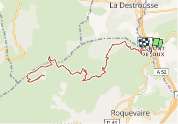
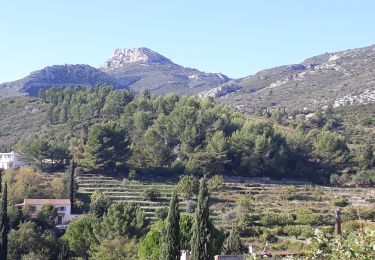
Trail Running of 14.7 km to be discovered at Provence-Alpes-Côte d'Azur, Bouches-du-Rhône, Roquevaire. This trail is proposed by tracegps.

Description

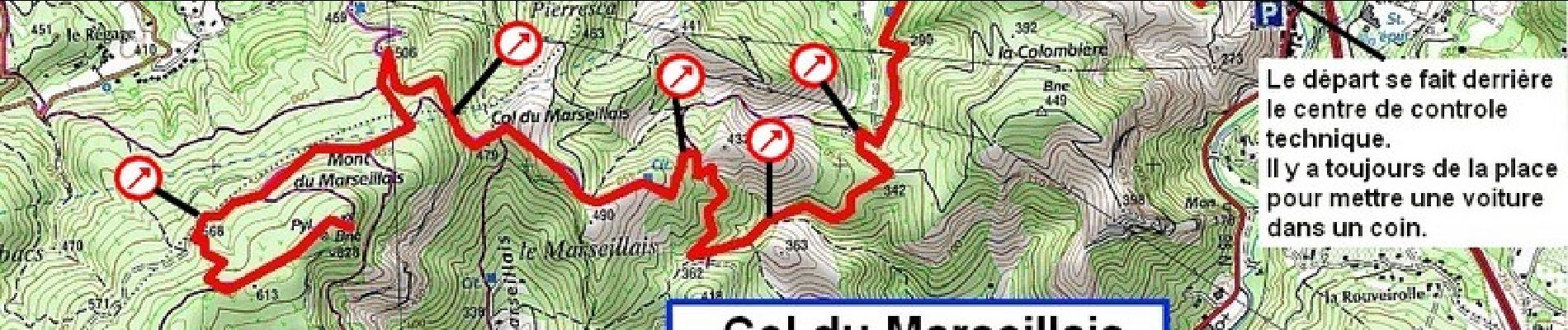
Le Mont du Marseillais est facilement repérable : ce sont les antennes des relais télé qu'on voit à droite (à l'Est) du Garlaban. Un itinéraire un peu plus long que d'habitude mais en totalité sur piste D.F.C.I. Quelques bons raidillons mais sur un terrain très agréable à courir. 650 m de dénivelé pratiquement non stop. A éviter en saison chaude et par fort mistral.

Elevation profile

Photos

Positioning

Country:
France
Region :
Provence-Alpes-Côte d'Azur
Department/Province :
Bouches-du-Rhône
Municipality :
Roquevaire
Location:
Unknown
Start:(UTM)
711629 ; 4804585 (31T) N.

Trails nearby

Trail Walking Auriol - la crete des infernets - Photo
Walking
Coryphene

Walking

Difficult
(1)
Auriol, Provence-Alpes-Côte d'Azur, Bouches-du-Rhône, France
8.6 km | 14 km-effort
3h 22min
Yes
Trail On foot Auriol - Les moulins - Photo
On foot
PRO

On foot

Easy
Auriol, Provence-Alpes-Côte d'Azur, Bouches-du-Rhône, France
3.7 km | 4.2 km-effort
57min
Yes
Trail Walking Auriol - le ravin des Encanaux - Photo
Walking
GUIDE
amiral13

Walking

Difficult
Auriol, Provence-Alpes-Côte d'Azur, Bouches-du-Rhône, France
7.3 km | 12.2 km-effort
3h 10min
Yes
Trail Walking Roquevaire - Garlaban au départ de Lascours  - Photo
Walking
GUIDE
nadinebondoux

Walking

Difficult
Roquevaire, Provence-Alpes-Côte d'Azur, Bouches-du-Rhône, France
15.6 km | 26 km-effort
6h 1min
Yes
Trail Walking Roquevaire - le mont du marseillais par le grand Vallon - Photo
Walking
GUIDE
amiral13

Walking

Difficult
Roquevaire, Provence-Alpes-Côte d'Azur, Bouches-du-Rhône, France
9.9 km | 15.9 km-effort
4h 50min
Yes
Trail Walking Roquevaire - Le Garlaban par le Grand Vallon - Photo
Walking
ARPF

Walking

Difficult
(1)
Roquevaire, Provence-Alpes-Côte d'Azur, Bouches-du-Rhône, France
10.1 km | 18.7 km-effort
3h 49min
Yes
Trail Walking Roquevaire - Marmittes du grand vallon - Photo
Walking
Equedreu

Walking

Easy
(1)
Roquevaire, Provence-Alpes-Côte d'Azur, Bouches-du-Rhône, France
8.5 km | 14.4 km-effort
2h 24min
Yes
Trail Walking Aubagne - Chemin des Solans. GARLABAN.  Retour par vallon.  - Photo
Walking
jll7513

Walking

Easy
(2)
Aubagne, Provence-Alpes-Côte d'Azur, Bouches-du-Rhône, France
6.7 km | 13.1 km-effort
2h 9min
Yes
Trail Walking Auriol - les Encanaux  - Photo
Walking
cousam

Walking

Difficult
Auriol, Provence-Alpes-Côte d'Azur, Bouches-du-Rhône, France
7.1 km | 11 km-effort
2h 14min
Yes


Close
My subscriptions