Trail Running Cahors - Cahors, le Lot, le causse, la vieille ville - Photo

Cahors, le Lot, le causse, la vieille ville

 tracegps
tracegps

User

© OpenStreetMap contributors
Length
Length
7.3 km
Max alt
Max alt
276 m
Uphill gradient
Uphill gradient
205 m
Km-Effort
Km-Effort  
10 km
Min alt
Min alt
112 m
Downhill gradient
Downhill gradient
205 m
Boucle
Boucle
Yes
Creation date :
2014-12-10 00:00:00.0
Updated on :
2014-12-10 00:00:00.0

(0 Reviews)

Running
Running
45m
Difficulty : Medium

Scan this QR Code to open this trail in the SityTrail application

FREE GPS app for hiking

Logo SityTrail SityTrail

IGN / Geographical institutes

Download SityTrail from the App Store Download SityTrail from Google Play

Logo SityTrail SityTrail World

The world is yours!

Download SityTrail from the App Store Download SityTrail from Google Play Download SityTrail on Huawei AppGallery

About

Trail Running of 7.3 km to be discovered at Occitania, Lot, Cahors. This trail is proposed by tracegps.

Description

Le circuit débute au Pont Valentré. Il suit le Lot par un joli chemin piéton aménagé au bord de l'eau (quelques centaines de mètres après le pont Valentré, au niveau de la buvette, descendre au bord de l'eau). Le Lot est traversé au pont suivant, le pont Louis Philippe. Un chemin dans un maquis sauvage s'élève jusqu'au mont Saint Cyr par une pente assez raide ( GR ). Magnifique panorama sur le Lot et la ville. On contourne un vallon en restant sur le causse, avant de redescendre sur le Lot, avec de nouveau de magnifiques points de vue sur la ville (balisage jaune). On traverse à nouveau le Lot et l'on rejoint le Pont Valentré à travers les ruelles de la vielle ville, sans oublier de se réhydrater à une des terrasses ensoleillées. Une vision différente, un peu sportive, de Cahors.

Elevation profile

Photos

Positioning

Country:
France
Region :
Occitania
Department/Province :
Lot
Municipality :
Cahors
Location:
Unknown
Start:(UTM)
375275 ; 4922525 (31T) N.

Trails nearby

Trail Mountain bike Cahors - Cahors-La Rozière 2005 - Photo
Mountain bike
tracegps

Mountain bike

Very difficult
(1)
Cahors, Occitania, Lot, France
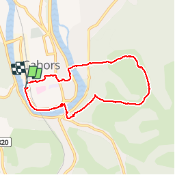
62 km | 81 km-effort
5h 0min
Yes
Trail Walking Pradines - Cahors les Durands 7km - Photo
Walking
PariseJL

Walking

Easy
(1)
Pradines, Occitania, Lot, France
7.1 km | 9.3 km-effort
2h 13min
Yes
Trail Nordic walking Pradines - 15km chemin des combettes - Photo
Nordic walking
Dominique Molinier

Nordic walking

Very easy
(1)
Pradines, Occitania, Lot, France
14.8 km | 17.9 km-effort
2h 15min
Yes
Trail Walking Bellefont-La Rauze - Larroque des arcs constant valroufie  - Photo
Walking
GUIDE
antignacs

Walking

Very easy
Bellefont-La Rauze, Occitania, Lot, France
11.6 km | 15 km-effort
2h 38min
Yes
Trail Walking Cahors - Croix magne  - Photo
Walking
GUIDE
antignacs

Walking

Very easy
Cahors, Occitania, Lot, France
5.2 km | 7.2 km-effort
1h 20min
No
Trail Walking Cahors - Étape Cahors Lascabannes  - Photo
Walking
Jean-MarieFaux

Walking

Easy
Cahors, Occitania, Lot, France
23 km | 30 km-effort
18h 50min
No
Trail Walking Cahors - CahorsMontcuq - Photo
Walking
patrickdanilo

Walking

Medium
Cahors, Occitania, Lot, France
22 km | 29 km-effort
4h 40min
No
Trail Mountain bike Trespoux-Rassiels - Circuit ouest de Trespoux Rassiels - Photo
Mountain bike
tracegps

Mountain bike

Very difficult
Trespoux-Rassiels, Occitania, Lot, France
38 km | 51 km-effort
4h 15min
Yes
Trail Walking Cahors - Cahors - Lascabanes - Chemin de Compostelle - Photo
Walking
tracegps

Walking

Very difficult
(1)
Cahors, Occitania, Lot, France
24 km | 31 km-effort
9h 30min
No


Close
My subscriptions