Trail Walking Dampleux - PN DAMPLEUX 15.9 km - Photo

PN DAMPLEUX 15.9 km

© OpenStreetMap contributors
Length
Length
15.9 km
Max alt
Max alt
200 m
Uphill gradient
Uphill gradient
311 m
Km-Effort
Km-Effort  
20 km
Min alt
Min alt
91 m
Downhill gradient
Downhill gradient
323 m
Boucle
Boucle
No
Creation date :
2019-01-15 17:32:05.417
Updated on :
2019-01-15 17:32:05.417

(0 Reviews)

Walking
Walking
4h19
Difficulty : Difficult

Scan this QR Code to open this trail in the SityTrail application

FREE GPS app for hiking

Logo SityTrail SityTrail

IGN / Geographical institutes

Download SityTrail from the App Store Download SityTrail from Google Play

Logo SityTrail SityTrail World

The world is yours!

Download SityTrail from the App Store Download SityTrail from Google Play Download SityTrail on Huawei AppGallery

About

Trail Walking of 15.9 km to be discovered at Hauts-de-France, Aisne, Dampleux. This trail is proposed by GOELERANDO2.

Description

Départ et parking rue des Cisterciens.

Elevation profile

Positioning

Country:
France
Region :
Hauts-de-France
Department/Province :
Aisne
Municipality :
Dampleux
Location:
Unknown
Start:(UTM)
511103 ; 5454590 (31U) N.

Trails nearby

Trail Walking Longpont - en forêt de Retz_19_Longpont_carrefour de Vauvaudran_AR - Photo
Walking

Walking

Medium
(1)
Longpont, Hauts-de-France, Aisne, France
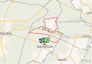
17.5 km | 21 km-effort
4h 10min
Yes
Trail Walking Villers-Cotterêts - maison forestière de mortefert > (vers) billemont > (vers) villers cotteret - (vers) baisemont > maison forestière de mortefert - Photo
Walking
DA FT

Walking

Medium
Villers-Cotterêts, Hauts-de-France, Aisne, France
16.8 km | 20 km-effort
4h 36min
Yes
Trail Walking Corcy - FLEURY .AISNE  - Photo
Walking
TURLUPIN2010

Walking

Medium
Corcy, Hauts-de-France, Aisne, France
5.7 km | 7.9 km-effort
1h 25min
Yes
Trail Walking Fleury - en Forêt de Retz_92_05_2022_Rond d'Orléans_Chapeau des Cordeliers_la Laie des étangs de Longpont - Photo
Walking

Walking

Medium
Fleury, Hauts-de-France, Aisne, France
9.2 km | 10.9 km-effort
2h 46min
Yes
Trail Walking Noroy-sur-Ourcq - en Forêt de Retz_93_05_2022_le Bois de Cresnes - Photo
Walking

Walking

Easy
Noroy-sur-Ourcq, Hauts-de-France, Aisne, France
4.2 km | 5.3 km-effort
1h 17min
Yes
Trail Walking Corcy - en forêt de Retz_91_04_2022_la Laie de la Belle Epine - Photo
Walking

Walking

Difficult
Corcy, Hauts-de-France, Aisne, France
10.6 km | 13.3 km-effort
3h 32min
Yes
Trail On foot Puiseux-en-Retz - Route du Faîte - Photo
On foot
PRO

On foot

Easy
Puiseux-en-Retz, Hauts-de-France, Aisne, France
5.8 km | 7.1 km-effort
1h 37min
No
Trail Walking Villers-Cotterêts - en Forêt de Retz_89_09_2021_les Ventes Racines et le Chablis des Bouleaux - Photo
Walking

Walking

Medium
Villers-Cotterêts, Hauts-de-France, Aisne, France
10.2 km | 12.1 km-effort
3h 14min
Yes
Trail Walking Villers-Cotterêts - Domaine de Coyolles - Photo
Walking
TURLUPIN2010

Walking

Medium
Villers-Cotterêts, Hauts-de-France, Aisne, France
14.3 km | 16.3 km-effort
3h 0min
Yes


Close
My subscriptions