Trail Mountain bike Ottrott - Mont Ste Odile - Rothlach - Photo

Mont Ste Odile - Rothlach

 tracegps
tracegps

User

© OpenStreetMap contributors
Length
Length
24 km
Max alt
Max alt
976 m
Uphill gradient
Uphill gradient
486 m
Km-Effort
Km-Effort  
31 km
Min alt
Min alt
671 m
Downhill gradient
Downhill gradient
487 m
Boucle
Boucle
Yes
Creation date :
2014-12-10 00:00:00.0
Updated on :
2014-12-10 00:00:00.0

(0 Reviews)

Mountain bike
Mountain bike
3h00
Difficulty : Medium

Scan this QR Code to open this trail in the SityTrail application

FREE GPS app for hiking

Logo SityTrail SityTrail

IGN / Geographical institutes

Download SityTrail from the App Store Download SityTrail from Google Play

Logo SityTrail SityTrail World

The world is yours!

Download SityTrail from the App Store Download SityTrail from Google Play Download SityTrail on Huawei AppGallery

About

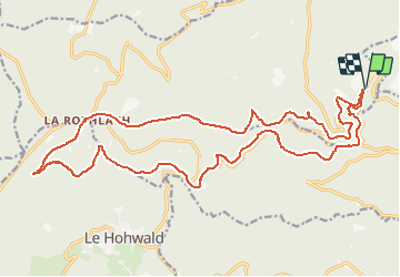
Trail Mountain bike of 24 km to be discovered at Grand Est, Bas-Rhin, Ottrott. This trail is proposed by tracegps.

Description

Circuit pas très long mais assez varié. On rejoint l'auberge du Welschbruch dans un premier temps puis l'auberge de la Rothlach et enfin une superbe descente pour terminer le circuit avant de rejoindre Ste Odile.

Elevation profile

Points of interest

Point of interest Obernai - 824 - Photo
tracegps
OBERNAI 
Point of interest Ottrott - 825 - Photo
tracegps
OTTROTT 
Point of interest Ottrott - 826 - Photo
tracegps
OTTROTT 
Point of interest Barr - 827 - Photo
tracegps
BARR 
Point of interest Barr - 828 - Photo
tracegps
BARR 
Point of interest Barr - 829 - Photo
tracegps
BARR 
Point of interest Barr - 830 - Photo
tracegps
BARR 
Point of interest Barr - 831 - Photo
tracegps
BARR 
Point of interest Barr - 832 - Photo
tracegps
BARR 
Point of interest Le Hohwald - 833 - Photo
tracegps
LE HOHWALD 
Point of interest Le Hohwald - 834 - Photo
tracegps
LE HOHWALD 
Point of interest Le Hohwald - 835 - Photo
tracegps
LE HOHWALD 
Point of interest Le Hohwald - 836 - Photo
tracegps
LE HOHWALD 
Point of interest Barr - 837 - Photo
tracegps
BARR 
Point of interest Barr - 838 - Photo
tracegps
BARR 
Point of interest Ottrott - 839 - Photo
tracegps
OTTROTT 
Point of interest Ottrott - 840 - Photo
tracegps
OTTROTT 
Point of interest Neuviller-la-Roche - CA 18 - Photo
tracegps
NEUVILLER-LA-ROCHE 
Point of interest Waldersbach - Col de la Pérheux - Photo
tracegps
WALDERSBACH 
Point of interest Rosheim - fontaine eau - Photo
tracegps
ROSHEIM 

Positioning

Country:
France
Region :
Grand Est
Department/Province :
Bas-Rhin
Municipality :
Ottrott
Location:
Unknown
Start:(UTM)
381780 ; 5365818 (32U) N.

Trails nearby

Trail Walking Ottrott - Le circuit sud du Mur Païen - Photo
Walking
VacheKiri67

Walking

Easy
(2)
Ottrott, Grand Est, Bas-Rhin, France
4.9 km | 6.3 km-effort
1h 56min
No
Trail Walking Ottrott - Le circuit nord du Mur Païen - Photo
Walking
VacheKiri67

Walking

Easy
(1)
Ottrott, Grand Est, Bas-Rhin, France
5.9 km | 8.5 km-effort
2h 4min
No
Trail Walking Ottrott - Le Mont Sainte-Odile depuis Otrott - Photo
Walking
VacheKiri67

Walking

Medium
(1)
Ottrott, Grand Est, Bas-Rhin, France
13 km | 20 km-effort
6h 18min
Yes
Trail Walking Ottrott - Montée vers le Mont Sainte-Odile - Photo
Walking
VacheKiri67

Walking

Difficult
(1)
Ottrott, Grand Est, Bas-Rhin, France
17.6 km | 26 km-effort
5h 52min
Yes
Trail Walking Ottrott - Le mur païen - Photo
Walking
VacheKiri67

Walking

Medium
(4)
Ottrott, Grand Est, Bas-Rhin, France
10.5 km | 14.5 km-effort
4h 36min
Yes
Trail Walking Ottrott - Mur Paien complet - Photo
Walking
markrei

Walking

Medium
(1)
Ottrott, Grand Est, Bas-Rhin, France
12 km | 16.4 km-effort
5h 25min
Yes
Trail Mountain bike Barr - Circuit des 3 Petits Ponts - Photo
Mountain bike
tracegps

Mountain bike

Difficult
(1)
Barr, Grand Est, Bas-Rhin, France
15.9 km | 22 km-effort
1h 19min
Yes
Trail Mountain bike Ottrott - Sainte-Odile East-Face - Photo
Mountain bike
tracegps

Mountain bike

Difficult
(1)
Ottrott, Grand Est, Bas-Rhin, France
24 km | 39 km-effort
3h 0min
Yes
Trail Walking Obernai - sentier des merveilles - Photo
Walking
semila

Walking

Difficult
(1)
Obernai, Grand Est, Bas-Rhin, France
11 km | 16.6 km-effort
4h 8min
Yes


Close
My subscriptions