Trail Mountain bike Riom - Entre Riom et Ennezat - Photo
 tracegps
tracegps

User

© OpenStreetMap contributors
Length
Length
36 km
Max alt
Max alt
400 m
Uphill gradient
Uphill gradient
221 m
Km-Effort
Km-Effort  
39 km
Min alt
Min alt
309 m
Downhill gradient
Downhill gradient
220 m
Boucle
Boucle
Yes
Creation date :
2014-12-10 00:00:00.0
Updated on :
2014-12-10 00:00:00.0

(0 Reviews)

Mountain bike
Mountain bike
2h19
Difficulty : Medium

Scan this QR Code to open this trail in the SityTrail application

FREE GPS app for hiking

Logo SityTrail SityTrail

IGN / Geographical institutes

Download SityTrail from the App Store Download SityTrail from Google Play

Logo SityTrail SityTrail World

The world is yours!

Download SityTrail from the App Store Download SityTrail from Google Play Download SityTrail on Huawei AppGallery

About

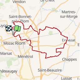
Trail Mountain bike of 36 km to be discovered at Auvergne-Rhône-Alpes, Puy-de-Dôme, Riom. This trail is proposed by tracegps.

Description

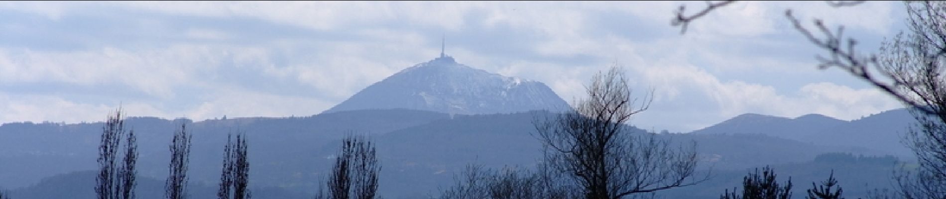
Circuit facile, en plaine. Peut se faire en famille, avec des pauses. A faire de préférence par temps sec. Vue sur la chaine des Puys et les Monts du Forez. Attention pour couper les routes sur le parcours.

Elevation profile

Photos

Positioning

Country:
France
Region :
Auvergne-Rhône-Alpes
Department/Province :
Puy-de-Dôme
Municipality :
Riom
Location:
Unknown
Start:(UTM)
507678 ; 5083442 (31T) N.

Trails nearby

Trail On foot Loubeyrat - La Vallee des Prades - Photo
On foot
PRO

On foot

Easy
(1)
Loubeyrat, Auvergne-Rhône-Alpes, Puy-de-Dôme, France
11.1 km | 15.6 km-effort
3h 33min
Yes
Trail Walking Enval - Enval_Gorges - Photo
Walking
GUIDE
jagarnier

Walking

Medium
(1)
Enval, Auvergne-Rhône-Alpes, Puy-de-Dôme, France
9.1 km | 13.2 km-effort
2h 45min
Yes
Trail Walking Loubeyrat - Le roc du diable - Prompsat - Photo
Walking
Gegetop

Walking

Medium
(1)
Loubeyrat, Auvergne-Rhône-Alpes, Puy-de-Dôme, France
9.5 km | 13.4 km-effort
2h 20min
Yes
Trail Walking Gimeaux - Chemin de Fontête - Photo
Walking
Gegetop

Walking

Easy
(2)
Gimeaux, Auvergne-Rhône-Alpes, Puy-de-Dôme, France
8.6 km | 11.9 km-effort
2h 6min
Yes
Trail Walking Châtel-Guyon - Les Briffons-Bois d'Agnat - Photo
Walking
Gegetop

Walking

Easy
(2)
Châtel-Guyon, Auvergne-Rhône-Alpes, Puy-de-Dôme, France
10.6 km | 14.8 km-effort
3h 14min
Yes
Trail Walking Châtel-Guyon - Chazeron sans souci - Photo
Walking
Gegetop

Walking

Easy
(1)
Châtel-Guyon, Auvergne-Rhône-Alpes, Puy-de-Dôme, France
6.6 km | 9.7 km-effort
1h 45min
Yes
Trail Walking Châtel-Guyon - Boucle de Rochepradière en passant par Douhady - Photo
Walking
Gegetop

Walking

Easy
(1)
Châtel-Guyon, Auvergne-Rhône-Alpes, Puy-de-Dôme, France
6.7 km | 9.7 km-effort
2h 6min
Yes
Trail Walking Châtel-Guyon - Le tour de Montaclier - Saint Hippolyte - Photo
Walking
tracegps

Walking

Difficult
(1)
Châtel-Guyon, Auvergne-Rhône-Alpes, Puy-de-Dôme, France
14 km | 19.6 km-effort
3h 30min
Yes
Trail On foot Châtel-Guyon - La Vallée du Sans-Souci - Photo
On foot
PRO

On foot

Easy
Châtel-Guyon, Auvergne-Rhône-Alpes, Puy-de-Dôme, France
4.4 km | 6.5 km-effort
1h 28min
Yes


Close
My subscriptions