Trail Walking Bussang - Cascade de l'Ours - Bussang - Photo

Cascade de l'Ours - Bussang

 tracegps
tracegps

User

© OpenStreetMap contributors
Length
Length
8.6 km
Max alt
Max alt
901 m
Uphill gradient
Uphill gradient
319 m
Km-Effort
Km-Effort  
12.8 km
Min alt
Min alt
595 m
Downhill gradient
Downhill gradient
319 m
Boucle
Boucle
Yes
Creation date :
2014-12-10 00:00:00.0
Updated on :
2014-12-10 00:00:00.0

(0 Reviews)

Walking
Walking
2h00
Difficulty : Medium

Scan this QR Code to open this trail in the SityTrail application

FREE GPS app for hiking

Logo SityTrail SityTrail

IGN / Geographical institutes

Download SityTrail from the App Store Download SityTrail from Google Play

Logo SityTrail SityTrail World

The world is yours!

Download SityTrail from the App Store Download SityTrail from Google Play Download SityTrail on Huawei AppGallery

About

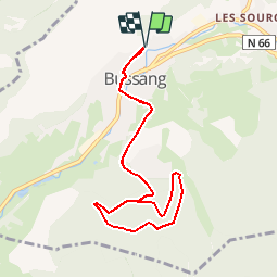
Trail Walking of 8.6 km to be discovered at Grand Est, Vosges, Bussang. This trail is proposed by tracegps.

Description

En partant de la place de Bussang, balade agréable au cœur des Vosges. A faire à toute période.

Elevation profile

Photos

Positioning

Country:
France
Region :
Grand Est
Department/Province :
Vosges
Municipality :
Bussang
Location:
Unknown
Start:(UTM)
339825 ; 5306171 (32T) N.

Trails nearby

Trail Walking Bussang - Col de Bussang - Rouge Gazon - Séchenat - Photo
Walking
VacheKiri67

Walking

Difficult
(1)
Bussang, Grand Est, Vosges, France
15 km | 24 km-effort
6h 0min
No
Trail Snowshoes Bussang - Circuit de raquette de Bussang - Photo
Snowshoes
tracegps

Snowshoes

Difficult
(1)
Bussang, Grand Est, Vosges, France
7.7 km | 11.2 km-effort
3h 0min
Yes
Trail Walking Storckensohn - lac des perches marchettes - Photo
Walking
lacote

Walking

Medium
(1)
Storckensohn, Grand Est, Haut-Rhin, France
11.9 km | 20 km-effort
4h 8min
Yes
Trail Walking Fellering - Felsach _chapelle ST Nicolas_frenz - Photo
Walking
Le grand Claude

Walking

Difficult
(1)
Fellering, Grand Est, Haut-Rhin, France
9.6 km | 16.5 km-effort
3h 45min
Yes
Trail Mountain bike Saint-Maurice-sur-Moselle - SityTrail - 3248441 - documentxix745004916x3256137 - Photo
Mountain bike
GUIDE
pascalou73

Mountain bike

Medium
Saint-Maurice-sur-Moselle, Grand Est, Vosges, France
21 km | 30 km-effort
2h 3min
Yes
Trail Mountain bike Bussang - activity_9407679223 - Photo
Mountain bike
GUIDE
pascalou73

Mountain bike

Medium
Bussang, Grand Est, Vosges, France
21 km | 30 km-effort
2h 2min
Yes
Trail Walking Ventron - 2022-02-19 Marche Ventron Tête des Champs - Photo
Walking
GUIDE
holtzv

Walking

Very difficult
Ventron, Grand Est, Vosges, France
22 km | 34 km-effort
5h 52min
Yes
Trail On foot Ventron - Circuit de la Croix de l’Hermite par Forgoutte - Photo
On foot
PRO

On foot

Easy
Ventron, Grand Est, Vosges, France
4.3 km | 6.6 km-effort
1h 29min
No
Trail On foot Ventron - Circuit panoramique de la Futaie - Photo
On foot
PRO

On foot

Easy
Ventron, Grand Est, Vosges, France
8.8 km | 12.6 km-effort
2h 52min
Yes


Close
My subscriptions